Kriftel geodata
Kriftel (Hesse) is a seat of a fourth-order administrative division; located in Germany in Europe/Berlin (GMT+2) time zone. With population of 10,633 people, there are 1555 cities with bigger population in this country. Compared to other cities in Germany, 61.6% of cities are located further ↑North; 71.4% of cities are located further →East and 65.4% of cities have higher elevation than Kriftel. Note1
Administrative division(s):
- Level 1: Hesse
- Level 2: Regierungsbezirk Darmstadt
- Level 3: Main-Taunus-Kreis
- Level 4: Kriftel


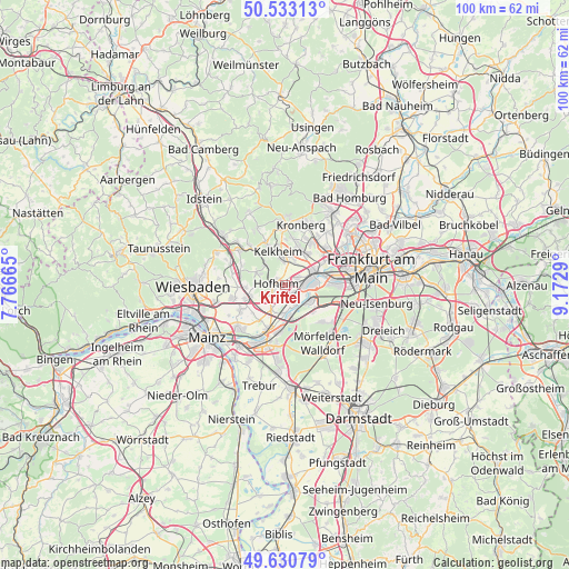
Kriftel GPS coordinates[2]
50° 5' 2.688" North, 8° 28' 11.172" East
| Map corner | latitude | longitude |
|---|---|---|
| Upper-left | 50.53313°, | 7.76665° |
| Center: | 50.08408°, | 8.46977° |
| Lower-right: | 49.63079°, | 9.1729° |
| Map W x H: | 100.3×100.3 km | = 62.3×62.3mi |
| max Lat: | 55.01917° ⇑61.6% North |
| Kriftel: | 50.08408° |
| min Lat: | ⇓38.4% South 47.40724° |
| min Long | Kriftel | max Long |
| 5.92978° | 8.46977° | 14.98853° |
| W 28.6%⇐ | ⇒71.4% E |
Elevation
Elevation of Kriftel is 118 m = 387 ft, and this is 131.1 m = 430 ft below average elevation for this country.
| Max E: |
1256 m = 4121 ft | 65.4% |
| Avg. | 249.1 m = 817 ft | |
| Kriftel | 118 m = 387 ft | |
Min E: |
-5 m = -16 ft | 34.6% |
See also: Germany elevation on elevation.city.
Geographical zone
Kriftel is located in North temperate zone (between Tropic of Cancer and the Arctic Circle). Distance of this North polar circle is 1832.3 km =1138.5 mi to North.| Distance of | km | miles | from Kriftel |
|---|---|---|---|
| North Pole | 4438.2 | 2757.8 | to North |
| Arctic Circle | 1832.3 | 1138.5 | to North |
| Tropic Cancer | 2962.9 | 1841.1 | to South |
| Equator | 5568.8 | 3460.3 | to South |


Nearby cities:
15 places around Kriftel: (largest is in red/bold)
• Bad Soden am Taunus
6.8 km =4.2 mi,  21°
21°
• Eppstein
8.5 km =5.3 mi,  319°
319°
• Eschborn
9.8 km =6.1 mi,  47°
47°
• Flörsheim
8.4 km =5.2 mi,  200°
200°
• Hattersheim
0.7 km =0.4 mi,  146°
146°
• Hofheim am Taunus
1.6 km =1 mi,  294°
294°
• Kelkheim (Taunus)
6.1 km =3.8 mi,  346°
346°
• Kelsterbach
4.9 km =3 mi,  120°
120°
• Kronberg Tal
10.9 km =6.8 mi,  12°
12°
• Königstein im Taunus
10.6 km =6.6 mi,  0°
0°
• Liederbach
4.6 km =2.9 mi, 22°
• Raunheim
8 km =5 mi,  188°
188°
• Rüsselsheim
11 km =6.8 mi, 197°
• Schwalbach am Taunus
8.6 km =5.3 mi,  31°
31°
• Sulzbach
6.9 km =4.3 mi,  36°
36°
Sources, notices
• [Note1] Compared only with cities in Germany existing in our database
• [Src1] Map data: © OpenStreetMap contributors (CC-BY-SA)
• [Src2] Other city data from geonames.org with taken over terms of usage.
• [Src3] Geographical zone / Annual Mean Temperature by Robert A. Rohde @ Wikipedia
