Eschborn geodata
Eschborn (Hesse) is a populated place; located in Germany in Europe/Berlin (GMT+2) time zone. With population of 20,383 people, there are 755 cities with bigger population in this country. Compared to other cities in Germany, 60.3% of cities are located further ↑North; 70.4% of cities are located further →East and 63.6% of cities have higher elevation than Eschborn. Note1
Administrative division(s):
- Level 1: Hesse
- Level 2: Regierungsbezirk Darmstadt
- Level 3: Main-Taunus-Kreis
- Level 4: Eschborn


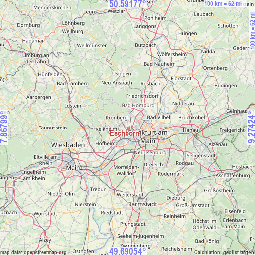
Eschborn GPS coordinates[2]
50° 8' 35.808" North, 8° 34' 15.996" East
| Map corner | latitude | longitude |
|---|---|---|
| Upper-left | 50.59177°, | 7.86799° |
| Center: | 50.14328°, | 8.57111° |
| Lower-right: | 49.69054°, | 9.27424° |
| Map W x H: | 100.2×100.2 km | = 62.3×62.3mi |
| max Lat: | 55.01917° ⇑60.3% North |
| Eschborn: | 50.14328° |
| min Lat: | ⇓39.7% South 47.40724° |
| min Long | Eschborn | max Long |
| 5.92978° | 8.57111° | 14.98853° |
| W 29.6%⇐ | ⇒70.4% E |
Elevation
Elevation of Eschborn is 128 m = 420 ft, and this is 121.1 m = 397 ft below average elevation for this country.
| Max E: |
1256 m = 4121 ft | 63.6% |
| Avg. | 249.1 m = 817 ft | |
| Eschborn | 128 m = 420 ft | |
Min E: |
-5 m = -16 ft | 36.4% |
See also: Germany elevation on elevation.city.
Geographical zone
Eschborn is located in North temperate zone (between Tropic of Cancer and the Arctic Circle). Distance of this North polar circle is 1825.8 km =1134.5 mi to North.| Distance of | km | miles | from Eschborn |
|---|---|---|---|
| North Pole | 4431.7 | 2753.7 | to North |
| Arctic Circle | 1825.8 | 1134.5 | to North |
| Tropic Cancer | 2969.5 | 1845.2 | to South |
| Equator | 5575.4 | 3464.4 | to South |


Nearby cities:
15 places around Eschborn: (largest is in red/bold)
• Bad Soden am Taunus
4.8 km =3 mi,  266°
266°
• Frankfurt am Main
8.6 km =5.3 mi,  110°
110°
• Gallus
6.3 km =3.9 mi,  138°
138°
• Kelkheim (Taunus)
8.6 km =5.3 mi, 265°
• Kelsterbach
9.6 km =6 mi,  198°
198°
• Kriftel
9.8 km =6.1 mi,  227°
227°
• Kronberg
5.7 km =3.5 mi,  323°
323°
• Kronberg Tal
6.3 km =3.9 mi,  309°
309°
• Königstein im Taunus
8.2 km =5.1 mi,  299°
299°
• Liederbach
6 km =3.7 mi,  246°
246°
• Niederrad
7.8 km =4.8 mi,  148°
148°
• Oberursel
7.1 km =4.4 mi,  3°
3°
• Schwalbach am Taunus
2.8 km =1.7 mi,  285°
285°
• Steinbach am Taunus
2.7 km =1.7 mi, 2°
• Sulzbach
3.2 km =2 mi, 251°
Sources, notices
• [Note1] Compared only with cities in Germany existing in our database
• [Src1] Map data: © OpenStreetMap contributors (CC-BY-SA)
• [Src2] Other city data from geonames.org with taken over terms of usage.
• [Src3] Geographical zone / Annual Mean Temperature by Robert A. Rohde @ Wikipedia
