Hofheim am Taunus geodata
Hofheim am Taunus (Hesse) is a seat of a third-order administrative division; located in Germany in Europe/Berlin (GMT+2) time zone. With population of 37,750 people, there are 352 cities with bigger population in this country. Compared to other cities in Germany, 61.5% of cities are located further ↑North; 71.5% of cities are located further →East and 61.1% of cities have higher elevation than Hofheim am Taunus. Note1
Administrative division(s):
- Level 1: Hesse
- Level 2: Regierungsbezirk Darmstadt
- Level 3: Main-Taunus-Kreis
- Level 4: Hofheim am Taunus, Kreisstadt


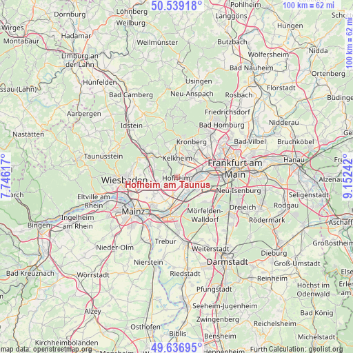
Hofheim am Taunus GPS coordinates[2]
50° 5' 24.684" North, 8° 26' 57.48" East
| Map corner | latitude | longitude |
|---|---|---|
| Upper-left | 50.53918°, | 7.74617° |
| Center: | 50.09019°, | 8.4493° |
| Lower-right: | 49.63695°, | 9.15242° |
| Map W x H: | 100.3×100.3 km | = 62.3×62.3mi |
| max Lat: | 55.01917° ⇑61.5% North |
| Hofheim am Taunus: | 50.09019° |
| min Lat: | ⇓38.5% South 47.40724° |
| min Long | Hofheim am Taun | max Long |
| 5.92978° | 8.4493° | 14.98853° |
| W 28.5%⇐ | ⇒71.5% E |
Elevation
Elevation of Hofheim am Taunus is 145 m = 476 ft, and this is 104.1 m = 342 ft below average elevation for this country.
| Max E: |
1256 m = 4121 ft | 61.1% |
| Avg. | 249.1 m = 817 ft | |
| Hofheim am Taunus | 145 m = 476 ft | |
Min E: |
-5 m = -16 ft | 38.9% |
See also: Germany elevation on elevation.city.
Geographical zone
Hofheim am Taunus is located in North temperate zone (between Tropic of Cancer and the Arctic Circle). Distance of this North polar circle is 1831.7 km =1138.2 mi to North.| Distance of | km | miles | from Hofheim am Taunus |
|---|---|---|---|
| North Pole | 4437.6 | 2757.4 | to North |
| Arctic Circle | 1831.7 | 1138.2 | to North |
| Tropic Cancer | 2963.6 | 1841.5 | to South |
| Equator | 5569.5 | 3460.7 | to South |


Nearby cities:
15 places around Hofheim am Taunus: (largest is in red/bold)
• Bad Soden am Taunus
6.9 km =4.3 mi,  34°
34°
• Eppstein
7.1 km =4.4 mi,  325°
325°
• Eschborn
10.5 km =6.5 mi,  55°
55°
• Flörsheim
8.7 km =5.4 mi,  190°
190°
• Hattersheim
2.3 km =1.4 mi,  124°
124°
• Hochheim am Main
10.9 km =6.8 mi,  219°
219°
• Kelkheim (Taunus)
5.2 km =3.2 mi,  0°
0°
• Kelsterbach
6.5 km =4 mi, 119°
• Kriftel
1.6 km =1 mi,  114°
114°
• Kronberg Tal
10.6 km =6.6 mi,  21°
21°
• Königstein im Taunus
10 km =6.2 mi,  8°
8°
• Liederbach
4.8 km =3 mi,  41°
41°
• Raunheim
8.6 km =5.3 mi,  178°
178°
• Schwalbach am Taunus
9 km =5.6 mi, 42°
• Sulzbach
7.4 km =4.6 mi,  49°
49°
Sources, notices
• [Note1] Compared only with cities in Germany existing in our database
• [Src1] Map data: © OpenStreetMap contributors (CC-BY-SA)
• [Src2] Other city data from geonames.org with taken over terms of usage.
• [Src3] Geographical zone / Annual Mean Temperature by Robert A. Rohde @ Wikipedia
