Krien geodata
Krien (Mecklenburg-Vorpommern) is a populated place; located in Germany in Europe/Berlin (GMT+2) time zone. With population of 849 people, there are 7709 cities with bigger population in this country. Compared to other cities in Germany, 90.3% of cities are located further ↓South; 95.4% of cities are located further ←West and 92.7% of cities have higher elevation than Krien. Note1
Administrative division(s):
- Level 1: Mecklenburg-Vorpommern
- Level 3: Vorpommern-Greifswald
- Level 4: Krien


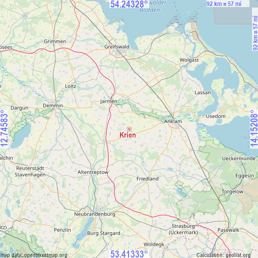
Krien GPS coordinates[2]
53° 49' 49.296" North, 13° 26' 56.22" East
| Map corner | latitude | longitude |
|---|---|---|
| Upper-left | 54.24328°, | 12.74583° |
| Center: | 53.83036°, | 13.44895° |
| Lower-right: | 53.41333°, | 14.15208° |
| Map W x H: | 92.3×92.3 km | = 57.4×57.4mi |
| max Lat: | 55.01917° ⇑9.7% North |
| Krien: | 53.83036° |
| min Lat: | ⇓90.3% South 47.40724° |
| min Long | Krien | max Long |
| 5.92978° | 13.44895° | 14.98853° |
| W 95.4%⇐ | ⇒4.6% E |
Elevation
Elevation of Krien is 14 m = 46 ft, and this is 235.1 m = 771 ft below average elevation for this country.
| Max E: |
1256 m = 4121 ft | 92.7% |
| Avg. | 249.1 m = 817 ft | |
| Krien | 14 m = 46 ft | |
Min E: |
-5 m = -16 ft | 7.3% |
See also: Germany elevation on elevation.city.
Geographical zone
Krien is located in North temperate zone (between Tropic of Cancer and the Arctic Circle). Distance of this North polar circle is 1415.8 km =879.7 mi to North.| Distance of | km | miles | from Krien |
|---|---|---|---|
| North Pole | 4021.7 | 2499 | to North |
| Arctic Circle | 1415.8 | 879.7 | to North |
| Tropic Cancer | 3379.5 | 2099.9 | to South |
| Equator | 5985.4 | 3719.2 | to South |


Nearby cities:
15 places around Krien: (largest is in red/bold)
• Alt Tellin
13.5 km =8.4 mi,  276°
276°
• Alt-Sanitz
9.3 km =5.8 mi,  101°
101°
• Anklam
16.1 km =10 mi,  79°
79°
• Bandelin
15.6 km =9.7 mi,  341°
341°
• Bartow
6.9 km =4.3 mi,  257°
257°
• Boldekow
15.2 km =9.4 mi,  140°
140°
• Burow
13.1 km =8.1 mi,  241°
241°
• Groß Polzin
11.8 km =7.3 mi,  53°
53°
• Jarmen
12.6 km =7.8 mi,  325°
325°
• Kessin
14.6 km =9.1 mi,  219°
219°
• Kruckow
15.8 km =9.8 mi,  300°
300°
• Neetzow
6.3 km =3.9 mi, 334°
• Siedenbollentin
11.7 km =7.3 mi,  202°
202°
• Spantekow
7.4 km =4.6 mi, 142°
• Völschow
9.1 km =5.7 mi,  305°
305°
Sources, notices
• [Note1] Compared only with cities in Germany existing in our database
• [Src1] Map data: © OpenStreetMap contributors (CC-BY-SA)
• [Src2] Other city data from geonames.org with taken over terms of usage.
• [Src3] Geographical zone / Annual Mean Temperature by Robert A. Rohde @ Wikipedia
