Völschow geodata
Völschow (Mecklenburg-Vorpommern) is a populated place; located in Germany in Europe/Berlin (GMT+2) time zone. With population of 602 people, there are 8809 cities with bigger population in this country. Compared to other cities in Germany, 90.9% of cities are located further ↓South; 94.6% of cities are located further ←West and 92% of cities have higher elevation than Völschow. Note1
Administrative division(s):
- Level 1: Mecklenburg-Vorpommern
- Level 3: Vorpommern-Greifswald
- Level 4: Völschow


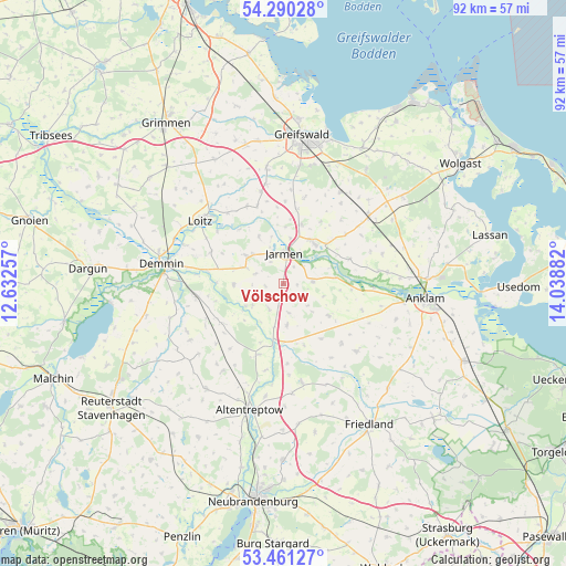
Völschow GPS coordinates[2]
53° 52' 40.188" North, 13° 20' 8.484" East
| Map corner | latitude | longitude |
|---|---|---|
| Upper-left | 54.29028°, | 12.63257° |
| Center: | 53.87783°, | 13.33569° |
| Lower-right: | 53.46127°, | 14.03882° |
| Map W x H: | 92.2×92.2 km | = 57.3×57.3mi |
| max Lat: | 55.01917° ⇑9.1% North |
| Völschow: | 53.87783° |
| min Lat: | ⇓90.9% South 47.40724° |
| min Long | Völschow | max Long |
| 5.92978° | 13.33569° | 14.98853° |
| W 94.6%⇐ | ⇒5.4% E |
Elevation
Elevation of Völschow is 16 m = 52 ft, and this is 233.1 m = 765 ft below average elevation for this country.
| Max E: |
1256 m = 4121 ft | 92% |
| Avg. | 249.1 m = 817 ft | |
| Völschow | 16 m = 52 ft | |
Min E: |
-5 m = -16 ft | 8% |
See also: Germany elevation on elevation.city.
Geographical zone
Völschow is located in North temperate zone (between Tropic of Cancer and the Arctic Circle). Distance of this North polar circle is 1410.5 km =876.4 mi to North.| Distance of | km | miles | from Völschow |
|---|---|---|---|
| North Pole | 4016.4 | 2495.7 | to North |
| Arctic Circle | 1410.5 | 876.4 | to North |
| Tropic Cancer | 3384.7 | 2103.2 | to South |
| Equator | 5990.7 | 3722.4 | to South |


Nearby cities:
15 places around Völschow: (largest is in red/bold)
• Alt Tellin
7.1 km =4.4 mi,  238°
238°
• Bandelin
9.9 km =6.2 mi,  14°
14°
• Bartow
6.8 km =4.2 mi,  174°
174°
• Behrenhoff
14.6 km =9.1 mi, 14°
• Bentzin
8.6 km =5.3 mi,  331°
331°
• Burow
12.3 km =7.6 mi,  199°
199°
• Görmin
13.3 km =8.3 mi,  341°
341°
• Jarmen
5.1 km =3.2 mi,  3°
3°
• Krien
9.1 km =5.7 mi,  125°
125°
• Kruckow
6.8 km =4.2 mi,  292°
292°
• Neetzow
4.7 km =2.9 mi,  85°
85°
• Siedenbollentin
16.4 km =10.2 mi, 169°
• Spantekow
16.3 km =10.1 mi, 133°
• Tutow
7.1 km =4.4 mi,  306°
306°
• Ückeritz
11.1 km =6.9 mi,  296°
296°
Sources, notices
• [Note1] Compared only with cities in Germany existing in our database
• [Src1] Map data: © OpenStreetMap contributors (CC-BY-SA)
• [Src2] Other city data from geonames.org with taken over terms of usage.
• [Src3] Geographical zone / Annual Mean Temperature by Robert A. Rohde @ Wikipedia
