Rochau geodata
Rochau (Saxony-Anhalt) is a seat of a fourth-order administrative division; located in Germany in Europe/Berlin (GMT+2) time zone. With population of 715 people, there are 8253 cities with bigger population in this country. Compared to other cities in Germany, 79.7% of cities are located further ↓South; 77.9% of cities are located further ←West and 83.2% of cities have higher elevation than Rochau. Note1


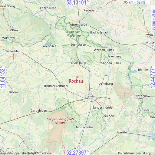
Rochau GPS coordinates[2]
52° 42' 25.452" North, 11° 44' 40.704" East
| Map corner | latitude | longitude |
|---|---|---|
| Upper-left | 53.13101°, | 11.04152° |
| Center: | 52.70707°, | 11.74464° |
| Lower-right: | 52.27897°, | 12.44777° |
| Map W x H: | 94.7×94.7 km | = 58.8×58.8mi |
| max Lat: | 55.01917° ⇑20.3% North |
| Rochau: | 52.70707° |
| min Lat: | ⇓79.7% South 47.40724° |
| min Long | Rochau | max Long |
| 5.92978° | 11.74464° | 14.98853° |
| W 77.9%⇐ | ⇒22.1% E |
Elevation
Elevation of Rochau is 39 m = 128 ft, and this is 210.1 m = 689 ft below average elevation for this country.
| Max E: |
1256 m = 4121 ft | 83.2% |
| Avg. | 249.1 m = 817 ft | |
| Rochau | 39 m = 128 ft | |
Min E: |
-5 m = -16 ft | 16.8% |
See also: Germany elevation on elevation.city.
Geographical zone
Rochau is located in North temperate zone (between Tropic of Cancer and the Arctic Circle). Distance of this North polar circle is 1540.7 km =957.3 mi to North.| Distance of | km | miles | from Rochau |
|---|---|---|---|
| North Pole | 4146.6 | 2576.6 | to North |
| Arctic Circle | 1540.7 | 957.3 | to North |
| Tropic Cancer | 3254.6 | 2022.3 | to South |
| Equator | 5860.5 | 3641.5 | to South |


Nearby cities:
15 places around Rochau: (largest is in red/bold)
• Badingen
12.9 km =8 mi,  212°
212°
• Bismark
13.6 km =8.5 mi,  248°
248°
• Erxleben
5 km =3.1 mi,  17°
17°
• Flessau
7.7 km =4.8 mi,  319°
319°
• Goldbeck
7.9 km =4.9 mi,  81°
81°
• Hohenberg-Krusemark
13.8 km =8.6 mi, 81°
• Jarchau
11.7 km =7.3 mi,  119°
119°
• Kläden
10.1 km =6.3 mi, 214°
• Krevese
12.2 km =7.6 mi,  343°
343°
• Königsmark
12.2 km =7.6 mi,  32°
32°
• Meßdorf
12.7 km =7.9 mi,  276°
276°
• Möringen
12.9 km =8 mi,  179°
179°
• Osterburg
8.9 km =5.5 mi,  3°
3°
• Stendal
13.5 km =8.4 mi,  145°
145°
• Uenglingen
10.8 km =6.7 mi,  156°
156°
Sources, notices
• [Note1] Compared only with cities in Germany existing in our database
• [Src1] Map data: © OpenStreetMap contributors (CC-BY-SA)
• [Src2] Other city data from geonames.org with taken over terms of usage.
• [Src3] Geographical zone / Annual Mean Temperature by Robert A. Rohde @ Wikipedia
