Großmonra geodata
Großmonra (Thuringia) is a populated place; located in Germany in Europe/Berlin (GMT+2) time zone. With population of 1,037 people, there are 7058 cities with bigger population in this country. Compared to other cities in Germany, 61.7% of cities are located further ↓South; 71.2% of cities are located further ←West and 55.4% of cities have higher elevation than Großmonra. Note1


Großmonra GPS coordinates[2]
51° 12' 46.764" North, 11° 17' 44.808" East
| Map corner | latitude | longitude |
|---|---|---|
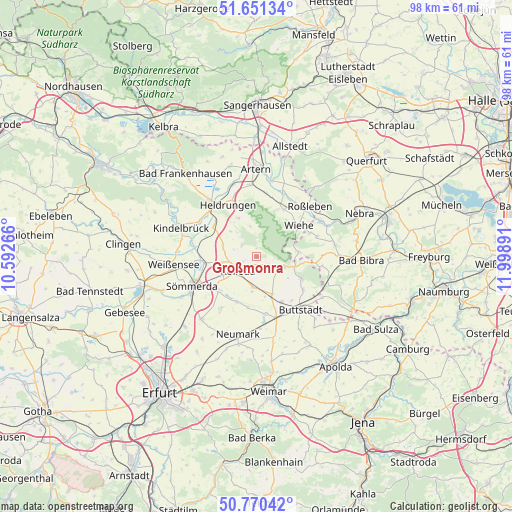
| Upper-left | 51.65134°, | 10.59266° |
| Center: | 51.21299°, | 11.29578° |
| Lower-right: | 50.77042°, | 11.99891° |
| Map W x H: | 97.9×97.9 km | = 60.8×60.8mi |
| max Lat: | 55.01917° ⇑38.3% North |
| Großmonra: | 51.21299° |
| min Lat: | ⇓61.7% South 47.40724° |
| min Long | Großmonra | max Long |
| 5.92978° | 11.29578° | 14.98853° |
| W 71.2%⇐ | ⇒28.8% E |
Elevation
Elevation of Großmonra is 186 m = 610 ft, and this is 63.1 m = 207 ft below average elevation for this country.
| Max E: |
1256 m = 4121 ft | 55.4% |
| Avg. | 249.1 m = 817 ft | |
| Großmonra | 186 m = 610 ft | |
Min E: |
-5 m = -16 ft | 44.6% |
See also: Germany elevation on elevation.city.
Geographical zone
Großmonra is located in North temperate zone (between Tropic of Cancer and the Arctic Circle). Distance of this North polar circle is 1706.8 km =1060.6 mi to North.| Distance of | km | miles | from Großmonra |
|---|---|---|---|
| North Pole | 4312.7 | 2679.8 | to North |
| Arctic Circle | 1706.8 | 1060.6 | to North |
| Tropic Cancer | 3088.4 | 1919 | to South |
| Equator | 5694.4 | 3538.3 | to South |


Nearby cities:
15 places around Großmonra: (largest is in red/bold)
• Beichlingen
3.4 km =2.1 mi,  309°
309°
• Ellersleben
7.2 km =4.5 mi,  168°
168°
• Großneuhausen
5.8 km =3.6 mi,  186°
186°
• Hauteroda
6 km =3.7 mi,  351°
351°
• Hemleben
6.9 km =4.3 mi, 306°
• Kleinbrembach
9.1 km =5.7 mi, 192°
• Kleinneuhausen
7.1 km =4.4 mi, 187°
• Kölleda
4.5 km =2.8 mi,  231°
231°
• Lossa
8 km =5 mi,  82°
82°
• Oberheldrungen
8.4 km =5.2 mi,  337°
337°
• Olbersleben
7.5 km =4.7 mi,  159°
159°
• Ostramondra
3 km =1.9 mi,  118°
118°
• Rastenberg
9.7 km =6 mi, 115°
• Schillingstedt
7 km =4.3 mi,  288°
288°
• Vogelsberg
9.4 km =5.8 mi,  199°
199°
Sources, notices
• [Note1] Compared only with cities in Germany existing in our database
• [Src1] Map data: © OpenStreetMap contributors (CC-BY-SA)
• [Src2] Other city data from geonames.org with taken over terms of usage.
• [Src3] Geographical zone / Annual Mean Temperature by Robert A. Rohde @ Wikipedia
