Köfering geodata
Köfering (Bavaria) is a seat of a fourth-order administrative division; located in Germany in Europe/Berlin (GMT+2) time zone. With population of 2,329 people, there are 4638 cities with bigger population in this country. Compared to other cities in Germany, 83.7% of cities are located further ↑North; 84.6% of cities are located further ←West and 69.4% of cities have lower elevation than Köfering. Note1
Administrative division(s):
- Level 1: Bavaria
- Level 2: Upper Palatinate
- Level 3: Landkreis Regensburg
- Level 4: Köfering


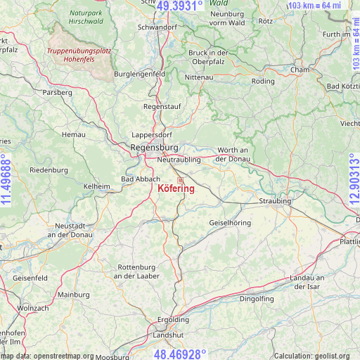
Köfering GPS coordinates[2]
48° 55' 59.988" North, 12° 12' 0" East
| Map corner | latitude | longitude |
|---|---|---|
| Upper-left | 49.3931°, | 11.49688° |
| Center: | 48.93333°, | 12.2° |
| Lower-right: | 48.46928°, | 12.90313° |
| Map W x H: | 102.7×102.7 km | = 63.8×63.8mi |
| max Lat: | 55.01917° ⇑83.7% North |
| Köfering: | 48.93333° |
| min Lat: | ⇓16.3% South 47.40724° |
| min Long | Köfering | max Long |
| 5.92978° | 12.2° | 14.98853° |
| W 84.6%⇐ | ⇒15.4% E |
Elevation
Elevation of Köfering is 354 m = 1161 ft, and this is 104.9 m = 344 ft above average elevation for this country.
| Max E: |
1256 m = 4121 ft | 30.6% |
| Köfering | 354 m 1161 ft | |
| Avg. | 249.1 m = 817 ft | |
Min E: |
-5 m = -16 ft | 69.4% |
See also: Germany elevation on elevation.city.
Geographical zone
Köfering is located in North temperate zone (between Tropic of Cancer and the Arctic Circle). Distance of this North polar circle is 1960.3 km =1218.1 mi to North.| Distance of | km | miles | from Köfering |
|---|---|---|---|
| North Pole | 4566.2 | 2837.3 | to North |
| Arctic Circle | 1960.3 | 1218.1 | to North |
| Tropic Cancer | 2835 | 1761.6 | to South |
| Equator | 5440.9 | 3380.8 | to South |


Nearby cities:
15 places around Köfering: (largest is in red/bold)
• Alteglofsheim
1.9 km =1.2 mi,  180°
180°
• Aufhausen
9.1 km =5.7 mi,  138°
138°
• Bad Abbach
11.3 km =7 mi,  272°
272°
• Barbing
7.4 km =4.6 mi,  0°
0°
• Donaustauf
11 km =6.8 mi, 1°
• Hagelstadt
3.9 km =2.4 mi,  161°
161°
• Mintraching
3.8 km =2.4 mi,  53°
53°
• Neutraubling
6 km =3.7 mi, 0°
• Obertraubling
4.4 km =2.7 mi,  326°
326°
• Pentling
11.7 km =7.3 mi,  298°
298°
• Pfakofen
8.6 km =5.3 mi,  166°
166°
• Regensburg
11.6 km =7.2 mi,  321°
321°
• Riekofen
11.1 km =6.9 mi,  99°
99°
• Tegernheim
10.3 km =6.4 mi,  348°
348°
• Thalmassing
4.1 km =2.5 mi,  233°
233°
Sources, notices
• [Note1] Compared only with cities in Germany existing in our database
• [Src1] Map data: © OpenStreetMap contributors (CC-BY-SA)
• [Src2] Other city data from geonames.org with taken over terms of usage.
• [Src3] Geographical zone / Annual Mean Temperature by Robert A. Rohde @ Wikipedia
