Aufhausen geodata
Aufhausen (Bavaria) is a seat of a fourth-order administrative division; located in Germany in Europe/Berlin (GMT+2) time zone. With population of 1,767 people, there are 5400 cities with bigger population in this country. Compared to other cities in Germany, 84.4% of cities are located further ↑North; 85.6% of cities are located further ←West and 72% of cities have lower elevation than Aufhausen. Note1
Administrative division(s):
- Level 1: Bavaria
- Level 2: Upper Palatinate
- Level 3: Landkreis Regensburg
- Level 4: Aufhausen


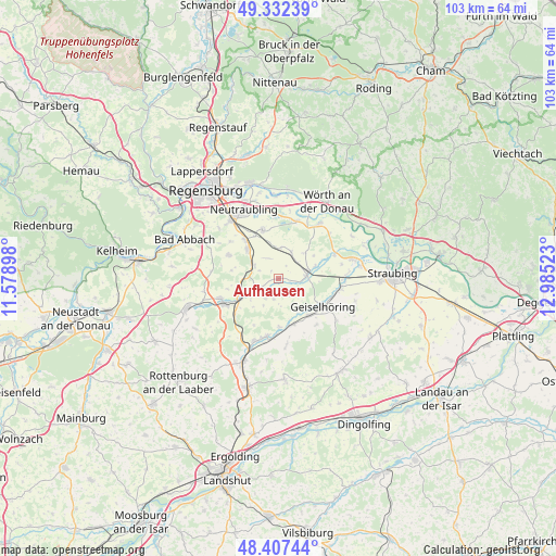
Aufhausen GPS coordinates[2]
48° 52' 19.38" North, 12° 16' 55.56" East
| Map corner | latitude | longitude |
|---|---|---|
| Upper-left | 49.33239°, | 11.57898° |
| Center: | 48.87205°, | 12.2821° |
| Lower-right: | 48.40744°, | 12.98523° |
| Map W x H: | 102.8×102.8 km | = 63.9×63.9mi |
| max Lat: | 55.01917° ⇑84.4% North |
| Aufhausen: | 48.87205° |
| min Lat: | ⇓15.6% South 47.40724° |
| min Long | Aufhausen | max Long |
| 5.92978° | 12.2821° | 14.98853° |
| W 85.6%⇐ | ⇒14.4% E |
Elevation
Elevation of Aufhausen is 374 m = 1227 ft, and this is 124.9 m = 410 ft above average elevation for this country.
| Max E: |
1256 m = 4121 ft | 28% |
| Aufhausen | 374 m 1227 ft | |
| Avg. | 249.1 m = 817 ft | |
Min E: |
-5 m = -16 ft | 72% |
See also: Germany elevation on elevation.city.
Geographical zone
Aufhausen is located in North temperate zone (between Tropic of Cancer and the Arctic Circle). Distance of this North polar circle is 1967.1 km =1222.3 mi to North.| Distance of | km | miles | from Aufhausen |
|---|---|---|---|
| North Pole | 4573 | 2841.5 | to North |
| Arctic Circle | 1967.1 | 1222.3 | to North |
| Tropic Cancer | 2828.1 | 1757.3 | to South |
| Equator | 5434.1 | 3376.6 | to South |


Nearby cities:
15 places around Aufhausen: (largest is in red/bold)
• Alteglofsheim
7.8 km =4.8 mi,  309°
309°
• Geiselhöring
9.9 km =6.2 mi,  121°
121°
• Hagelstadt
5.7 km =3.5 mi,  303°
303°
• Köfering
9.1 km =5.7 mi,  318°
318°
• Laberweinting
8.4 km =5.2 mi,  162°
162°
• Mallersdorf-Pfaffenberg
12.3 km =7.6 mi,  197°
197°
• Mintraching
9.5 km =5.9 mi,  342°
342°
• Mötzing
7.1 km =4.4 mi,  70°
70°
• Perkam
11.7 km =7.3 mi,  99°
99°
• Pfakofen
4.3 km =2.7 mi,  248°
248°
• Pfatter
12.5 km =7.8 mi,  35°
35°
• Riekofen
7 km =4.3 mi,  45°
45°
• Schierling
11.3 km =7 mi, 248°
• Sünching
5.1 km =3.2 mi,  81°
81°
• Thalmassing
10.3 km =6.4 mi, 295°
Sources, notices
• [Note1] Compared only with cities in Germany existing in our database
• [Src1] Map data: © OpenStreetMap contributors (CC-BY-SA)
• [Src2] Other city data from geonames.org with taken over terms of usage.
• [Src3] Geographical zone / Annual Mean Temperature by Robert A. Rohde @ Wikipedia
