Regensburg geodata
Regensburg (Bavaria) is a seat of a second-order administrative division; located in Germany in Europe/Berlin (GMT+2) time zone. With population of 129,151 people, there are 68 cities with bigger population in this country. Compared to other cities in Germany, 82.9% of cities are located further ↑North; 83.3% of cities are located further ←West and 67.7% of cities have lower elevation than Regensburg. Note1
Administrative division(s):
- Level 1: Bavaria
- Level 2: Upper Palatinate
- Level 3: Kreisfreie Stadt Regensburg
- Level 4: Regensburg


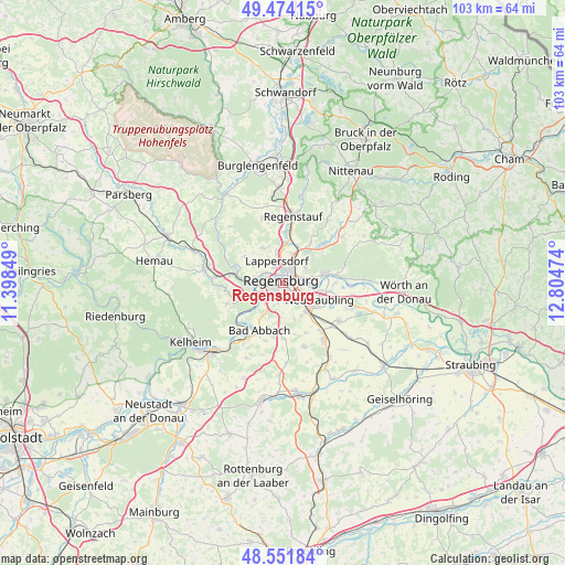
Regensburg GPS coordinates[2]
49° 0' 54.468" North, 12° 6' 5.796" East
| Map corner | latitude | longitude |
|---|---|---|
| Upper-left | 49.47415°, | 11.39849° |
| Center: | 49.01513°, | 12.10161° |
| Lower-right: | 48.55184°, | 12.80474° |
| Map W x H: | 102.6×102.5 km | = 63.8×63.7mi |
| max Lat: | 55.01917° ⇑82.9% North |
| Regensburg: | 49.01513° |
| min Lat: | ⇓17.1% South 47.40724° |
| min Long | Regensburg | max Long |
| 5.92978° | 12.10161° | 14.98853° |
| W 83.3%⇐ | ⇒16.7% E |
Elevation
Elevation of Regensburg is 341 m = 1119 ft, and this is 91.9 m = 302 ft above average elevation for this country.
| Max E: |
1256 m = 4121 ft | 32.3% |
| Regensburg | 341 m 1119 ft | |
| Avg. | 249.1 m = 817 ft | |
Min E: |
-5 m = -16 ft | 67.7% |
See also: Regensburg elevation on elevation.city.
Geographical zone
Regensburg is located in North temperate zone (between Tropic of Cancer and the Arctic Circle). Distance of this North polar circle is 1951.2 km =1212.4 mi to North.| Distance of | km | miles | from Regensburg |
|---|---|---|---|
| North Pole | 4557.1 | 2831.6 | to North |
| Arctic Circle | 1951.2 | 1212.4 | to North |
| Tropic Cancer | 2844.1 | 1767.2 | to South |
| Equator | 5450 | 3386.5 | to South |


Nearby cities:
15 places around Regensburg: (largest is in red/bold)
• Bad Abbach
9.6 km =6 mi,  205°
205°
• Barbing
7.4 km =4.6 mi,  103°
103°
• Donaustauf
7.8 km =4.8 mi,  75°
75°
• Köfering
11.6 km =7.2 mi,  141°
141°
• Lappersdorf
3.6 km =2.2 mi,  348°
348°
• Neutraubling
7.9 km =4.9 mi,  113°
113°
• Nittendorf
10.3 km =6.4 mi,  275°
275°
• Obertraubling
7.2 km =4.5 mi, 138°
• Pentling
4.7 km =2.9 mi,  221°
221°
• Pettendorf
8.5 km =5.3 mi,  306°
306°
• Reinhausen
2 km =1.2 mi,  25°
25°
• Sinzing
5.3 km =3.3 mi,  251°
251°
• Tegernheim
5.3 km =3.3 mi, 79°
• Wenzenbach
9.8 km =6.1 mi,  46°
46°
• Zeitlarn
7.1 km =4.4 mi,  5°
5°
In other languages:
- In Spanish: Ratisbona
- In France: Ratisbonne
- In Italian: Ratisbona
- In Russian: Регенсбург
- In Chinese: 雷根斯堡
Sources, notices
• [Note1] Compared only with cities in Germany existing in our database
• [Src1] Map data: © OpenStreetMap contributors (CC-BY-SA)
• [Src2] Other city data from geonames.org with taken over terms of usage.
• [Src3] Geographical zone / Annual Mean Temperature by Robert A. Rohde @ Wikipedia
