Plothen geodata
Plothen (Thuringia) is a seat of a fourth-order administrative division; located in Germany in Europe/Berlin (GMT+2) time zone. With population of 328 people, there are 9956 cities with bigger population in this country. Compared to other cities in Germany, 50.3% of cities are located further ↓South; 78.3% of cities are located further ←West and 86.8% of cities have lower elevation than Plothen. Note1


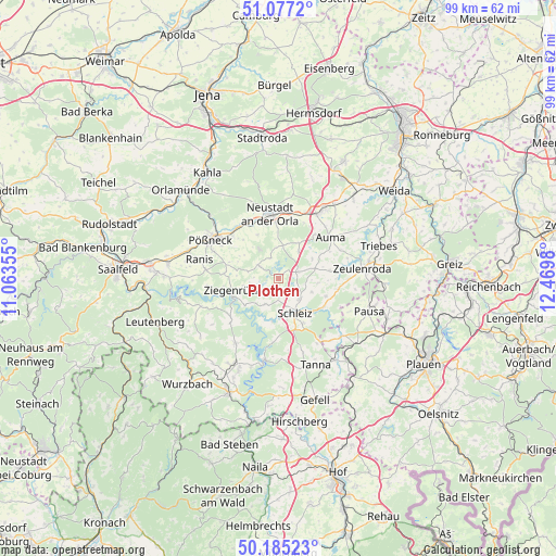
Plothen GPS coordinates[2]
50° 37' 59.988" North, 11° 46' 0.012" East
| Map corner | latitude | longitude |
|---|---|---|
| Upper-left | 51.0772°, | 11.06355° |
| Center: | 50.63333°, | 11.76667° |
| Lower-right: | 50.18523°, | 12.4698° |
| Map W x H: | 99.2×99.2 km | = 61.6×61.6mi |
| max Lat: | 55.01917° ⇑49.7% North |
| Plothen: | 50.63333° |
| min Lat: | ⇓50.3% South 47.40724° |
| min Long | Plothen | max Long |
| 5.92978° | 11.76667° | 14.98853° |
| W 78.3%⇐ | ⇒21.7% E |
Elevation
Elevation of Plothen is 484 m = 1588 ft, and this is 234.9 m = 771 ft above average elevation for this country.
| Max E: |
1256 m = 4121 ft | 13.2% |
| Plothen | 484 m 1588 ft | |
| Avg. | 249.1 m = 817 ft | |
Min E: |
-5 m = -16 ft | 86.8% |
See also: Germany elevation on elevation.city.
Geographical zone
Plothen is located in North temperate zone (between Tropic of Cancer and the Arctic Circle). Distance of this North polar circle is 1771.3 km =1100.6 mi to North.| Distance of | km | miles | from Plothen |
|---|---|---|---|
| North Pole | 4377.2 | 2719.9 | to North |
| Arctic Circle | 1771.3 | 1100.6 | to North |
| Tropic Cancer | 3024 | 1879 | to South |
| Equator | 5629.9 | 3498.3 | to South |


Nearby cities:
15 places around Plothen: (largest is in red/bold)
• Bucha
4.7 km =2.9 mi,  270°
270°
• Chursdorf
6.9 km =4.3 mi,  57°
57°
• Crispendorf
5.2 km =3.2 mi,  206°
206°
• Dittersdorf
4 km =2.5 mi, 62°
• Dreba
3.9 km =2.4 mi,  342°
342°
• Görkwitz
5.7 km =3.5 mi,  168°
168°
• Göschitz
7.1 km =4.4 mi,  90°
90°
• Knau
3.8 km =2.4 mi,  299°
299°
• Löhma
6.5 km =4 mi,  111°
111°
• Moßbach
6.6 km =4.1 mi,  32°
32°
• Oettersdorf
5.1 km =3.2 mi,  136°
136°
• Pörmitz
4 km =2.5 mi,  117°
117°
• Schleiz
6.8 km =4.2 mi,  153°
153°
• Schöndorf
5.4 km =3.4 mi,  250°
250°
• Volkmannsdorf
3.5 km =2.2 mi,  224°
224°
Sources, notices
• [Note1] Compared only with cities in Germany existing in our database
• [Src1] Map data: © OpenStreetMap contributors (CC-BY-SA)
• [Src2] Other city data from geonames.org with taken over terms of usage.
• [Src3] Geographical zone / Annual Mean Temperature by Robert A. Rohde @ Wikipedia
