Kempenich geodata
Kempenich (Rheinland-Pfalz) is a seat of a fourth-order administrative division; located in Germany in Europe/Berlin (GMT+2) time zone. With population of 1,903 people, there are 5199 cities with bigger population in this country. Compared to other cities in Germany, 54.2% of cities are located further ↑North; 92.2% of cities are located further →East and 86.3% of cities have lower elevation than Kempenich. Note1
Administrative division(s):
- Level 1: Rheinland-Pfalz
- Level 3: Landkreis Ahrweiler
- Level 4: Kempenich


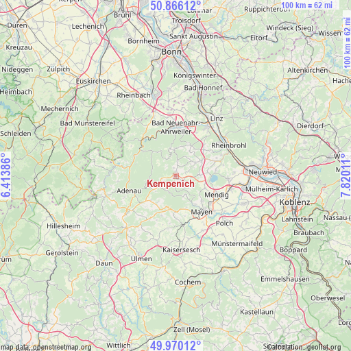
Kempenich GPS coordinates[2]
50° 25' 12.864" North, 7° 7' 1.128" East
| Map corner | latitude | longitude |
|---|---|---|
| Upper-left | 50.86612°, | 6.41386° |
| Center: | 50.42024°, | 7.11698° |
| Lower-right: | 49.97012°, | 7.82011° |
| Map W x H: | 99.6×99.6 km | = 61.9×61.9mi |
| max Lat: | 55.01917° ⇑54.2% North |
| Kempenich: | 50.42024° |
| min Lat: | ⇓45.8% South 47.40724° |
| min Long | Kempenich | max Long |
| 5.92978° | 7.11698° | 14.98853° |
| W 7.8%⇐ | ⇒92.2% E |
Elevation
Elevation of Kempenich is 480 m = 1575 ft, and this is 230.9 m = 758 ft above average elevation for this country.
| Max E: |
1256 m = 4121 ft | 13.7% |
| Kempenich | 480 m 1575 ft | |
| Avg. | 249.1 m = 817 ft | |
Min E: |
-5 m = -16 ft | 86.3% |
See also: Germany elevation on elevation.city.
Geographical zone
Kempenich is located in North temperate zone (between Tropic of Cancer and the Arctic Circle). Distance of this North polar circle is 1795 km =1115.4 mi to North.| Distance of | km | miles | from Kempenich |
|---|---|---|---|
| North Pole | 4400.9 | 2734.6 | to North |
| Arctic Circle | 1795 | 1115.4 | to North |
| Tropic Cancer | 3000.3 | 1864.3 | to South |
| Equator | 5606.2 | 3483.5 | to South |


Nearby cities:
15 places around Kempenich: (largest is in red/bold)
• Arft
4.7 km =2.9 mi,  210°
210°
• Brenk
4.9 km =3 mi,  72°
72°
• Galenberg
6.1 km =3.8 mi,  76°
76°
• Hausten
2.3 km =1.4 mi,  180°
180°
• Hohenleimbach
3.6 km =2.2 mi,  263°
263°
• Kirchwald
6.4 km =4 mi,  158°
158°
• Langenfeld
5.1 km =3.2 mi,  200°
200°
• Langscheid
4.1 km =2.5 mi, 180°
• Niederdürenbach
5.7 km =3.5 mi,  54°
54°
• Oberdürenbach
6.2 km =3.9 mi,  34°
34°
• Oberzissen
6.7 km =4.2 mi,  60°
60°
• Rieden
5.2 km =3.2 mi,  115°
115°
• Spessart
2.2 km =1.4 mi,  347°
347°
• Volkesfeld
3.2 km =2 mi,  133°
133°
• Weibern
2.5 km =1.6 mi, 122°
Sources, notices
• [Note1] Compared only with cities in Germany existing in our database
• [Src1] Map data: © OpenStreetMap contributors (CC-BY-SA)
• [Src2] Other city data from geonames.org with taken over terms of usage.
• [Src3] Geographical zone / Annual Mean Temperature by Robert A. Rohde @ Wikipedia
