Niederdürenbach geodata
Niederdürenbach (Rheinland-Pfalz) is a seat of a fourth-order administrative division; located in Germany in Europe/Berlin (GMT+2) time zone. With population of 1,056 people, there are 6978 cities with bigger population in this country. Compared to other cities in Germany, 53.8% of cities are located further ↑North; 91.6% of cities are located further →East and 62.1% of cities have lower elevation than Niederdürenbach. Note1
Administrative division(s):
- Level 1: Rheinland-Pfalz
- Level 3: Landkreis Ahrweiler
- Level 4: Niederdürenbach


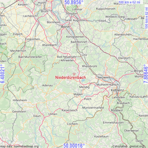
Niederdürenbach GPS coordinates[2]
50° 27' 0" North, 7° 10' 59.988" East
| Map corner | latitude | longitude |
|---|---|---|
| Upper-left | 50.8956°, | 6.48021° |
| Center: | 50.45°, | 7.18333° |
| Lower-right: | 50.00016°, | 7.88646° |
| Map W x H: | 99.6×99.6 km | = 61.9×61.9mi |
| max Lat: | 55.01917° ⇑53.8% North |
| Niederdürenbach: | 50.45° |
| min Lat: | ⇓46.2% South 47.40724° |
| min Long | Niederdürenbac | max Long |
| 5.92978° | 7.18333° | 14.98853° |
| W 8.4%⇐ | ⇒91.6% E |
Elevation
Elevation of Niederdürenbach is 302 m = 991 ft, and this is 52.9 m = 174 ft above average elevation for this country.
| Max E: |
1256 m = 4121 ft | 37.9% |
| Niederdürenbach | 302 m 991 ft | |
| Avg. | 249.1 m = 817 ft | |
Min E: |
-5 m = -16 ft | 62.1% |
See also: Germany elevation on elevation.city.
Geographical zone
Niederdürenbach is located in North temperate zone (between Tropic of Cancer and the Arctic Circle). Distance of this North polar circle is 1791.7 km =1113.3 mi to North.| Distance of | km | miles | from Niederdürenbach |
|---|---|---|---|
| North Pole | 4397.5 | 2732.5 | to North |
| Arctic Circle | 1791.7 | 1113.3 | to North |
| Tropic Cancer | 3003.6 | 1866.3 | to South |
| Equator | 5609.5 | 3485.6 | to South |


Nearby cities:
15 places around Niederdürenbach: (largest is in red/bold)
• Brenk
1.9 km =1.2 mi,  180°
180°
• Dedenbach
3.7 km =2.3 mi,  0°
0°
• Galenberg
2.2 km =1.4 mi,  147°
147°
• Glees
5.1 km =3.2 mi,  111°
111°
• Kempenich
5.7 km =3.5 mi,  234°
234°
• Königsfeld
5.3 km =3.3 mi,  355°
355°
• Niederzissen
2.6 km =1.6 mi,  68°
68°
• Oberdürenbach
2.2 km =1.4 mi,  327°
327°
• Oberzissen
1.2 km =0.7 mi,  90°
90°
• Rieden
5.6 km =3.5 mi, 180°
• Schalkenbach
5.6 km =3.5 mi, 332°
• Spessart
5.3 km =3.3 mi,  257°
257°
• Waldorf
5.1 km =3.2 mi,  43°
43°
• Wehr
4.4 km =2.7 mi, 147°
• Weibern
5.3 km =3.3 mi,  209°
209°
Sources, notices
• [Note1] Compared only with cities in Germany existing in our database
• [Src1] Map data: © OpenStreetMap contributors (CC-BY-SA)
• [Src2] Other city data from geonames.org with taken over terms of usage.
• [Src3] Geographical zone / Annual Mean Temperature by Robert A. Rohde @ Wikipedia
