Brenk geodata
Brenk (Rheinland-Pfalz) is a seat of a fourth-order administrative division; located in Germany in Europe/Berlin (GMT+2) time zone. With population of 204 people, there are 10457 cities with bigger population in this country. Compared to other cities in Germany, 54% of cities are located further ↑North; 91.6% of cities are located further →East and 75.6% of cities have lower elevation than Brenk. Note1


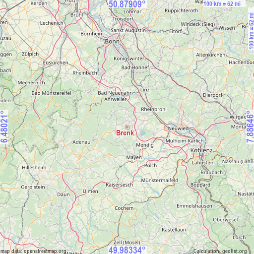
Brenk GPS coordinates[2]
50° 25' 59.988" North, 7° 10' 59.988" East
| Map corner | latitude | longitude |
|---|---|---|
| Upper-left | 50.87909°, | 6.48021° |
| Center: | 50.43333°, | 7.18333° |
| Lower-right: | 49.98334°, | 7.88646° |
| Map W x H: | 99.6×99.6 km | = 61.9×61.9mi |
| max Lat: | 55.01917° ⇑54% North |
| Brenk: | 50.43333° |
| min Lat: | ⇓46% South 47.40724° |
| min Long | Brenk | max Long |
| 5.92978° | 7.18333° | 14.98853° |
| W 8.4%⇐ | ⇒91.6% E |
Elevation
Elevation of Brenk is 402 m = 1319 ft, and this is 152.9 m = 502 ft above average elevation for this country.
| Max E: |
1256 m = 4121 ft | 24.4% |
| Brenk | 402 m 1319 ft | |
| Avg. | 249.1 m = 817 ft | |
Min E: |
-5 m = -16 ft | 75.6% |
See also: Germany elevation on elevation.city.
Geographical zone
Brenk is located in North temperate zone (between Tropic of Cancer and the Arctic Circle). Distance of this North polar circle is 1793.5 km =1114.4 mi to North.| Distance of | km | miles | from Brenk |
|---|---|---|---|
| North Pole | 4399.4 | 2733.7 | to North |
| Arctic Circle | 1793.5 | 1114.4 | to North |
| Tropic Cancer | 3001.7 | 1865.2 | to South |
| Equator | 5607.7 | 3484.5 | to South |


Nearby cities:
15 places around Brenk: (largest is in red/bold)
• Dedenbach
5.6 km =3.5 mi,  0°
0°
• Galenberg
1.2 km =0.7 mi,  90°
90°
• Glees
4.7 km =2.9 mi, 90°
• Hausten
6 km =3.7 mi,  231°
231°
• Kempenich
4.9 km =3 mi,  252°
252°
• Niederdürenbach
1.9 km =1.2 mi, 0°
• Niederzissen
3.7 km =2.3 mi,  41°
41°
• Oberdürenbach
3.9 km =2.4 mi,  342°
342°
• Oberzissen
2.2 km =1.4 mi,  32°
32°
• Rieden
3.7 km =2.3 mi,  180°
180°
• Spessart
5.2 km =3.2 mi,  277°
277°
• Volkesfeld
4.4 km =2.7 mi,  212°
212°
• Waldorf
6.6 km =4.1 mi, 32°
• Wehr
3 km =1.9 mi,  128°
128°
• Weibern
3.8 km =2.4 mi,  222°
222°
Sources, notices
• [Note1] Compared only with cities in Germany existing in our database
• [Src1] Map data: © OpenStreetMap contributors (CC-BY-SA)
• [Src2] Other city data from geonames.org with taken over terms of usage.
• [Src3] Geographical zone / Annual Mean Temperature by Robert A. Rohde @ Wikipedia
