Kefenrod geodata
Kefenrod (Hesse) is a seat of a fourth-order administrative division; located in Germany in Europe/Berlin (GMT+2) time zone. With population of 3,101 people, there are 3913 cities with bigger population in this country. Compared to other cities in Germany, 55.8% of cities are located further ↑North; 62.2% of cities are located further →East and 55.4% of cities have lower elevation than Kefenrod. Note1
Administrative division(s):
- Level 1: Hesse
- Level 2: Regierungsbezirk Darmstadt
- Level 3: Wetteraukreis
- Level 4: Kefenrod


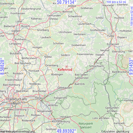
Kefenrod GPS coordinates[2]
50° 20' 41.1" North, 9° 12' 41.076" East
| Map corner | latitude | longitude |
|---|---|---|
| Upper-left | 50.79134°, | 8.50828° |
| Center: | 50.34475°, | 9.21141° |
| Lower-right: | 49.89392°, | 9.91453° |
| Map W x H: | 99.8×99.8 km | = 62×62mi |
| max Lat: | 55.01917° ⇑55.8% North |
| Kefenrod: | 50.34475° |
| min Lat: | ⇓44.2% South 47.40724° |
| min Long | Kefenrod | max Long |
| 5.92978° | 9.21141° | 14.98853° |
| W 37.8%⇐ | ⇒62.2% E |
Elevation
Elevation of Kefenrod is 261 m = 856 ft, and this is 11.9 m = 39 ft above average elevation for this country.
| Max E: |
1256 m = 4121 ft | 44.6% |
| Kefenrod | 261 m 856 ft | |
| Avg. | 249.1 m = 817 ft | |
Min E: |
-5 m = -16 ft | 55.4% |
See also: Germany elevation on elevation.city.
Geographical zone
Kefenrod is located in North temperate zone (between Tropic of Cancer and the Arctic Circle). Distance of this North polar circle is 1803.4 km =1120.6 mi to North.| Distance of | km | miles | from Kefenrod |
|---|---|---|---|
| North Pole | 4409.3 | 2739.8 | to North |
| Arctic Circle | 1803.4 | 1120.6 | to North |
| Tropic Cancer | 2991.9 | 1859.1 | to South |
| Equator | 5597.8 | 3478.3 | to South |


Nearby cities:
15 places around Kefenrod: (largest is in red/bold)
• Bad Orb
16.2 km =10.1 mi,  143°
143°
• Bad Soden-Salmünster
13.5 km =8.4 mi,  124°
124°
• Birstein
6.3 km =3.9 mi,  84°
84°
• Büdingen
9.3 km =5.8 mi,  229°
229°
• Freiensteinau
16.2 km =10.1 mi,  56°
56°
• Gedern
9 km =5.6 mi,  354°
354°
• Gelnhausen
16 km =9.9 mi,  186°
186°
• Glauburg
15.3 km =9.5 mi,  258°
258°
• Hain-Gründau
12.3 km =7.6 mi,  203°
203°
• Hirzenhain
8.3 km =5.2 mi,  317°
317°
• Nidda
16.4 km =10.2 mi,  297°
297°
• Nieder-Gründau
16.6 km =10.3 mi,  206°
206°
• Ortenberg
11.1 km =6.9 mi,  276°
276°
• Ranstadt
16.2 km =10.1 mi,  274°
274°
• Wächtersbach
11.6 km =7.2 mi,  149°
149°
Sources, notices
• [Note1] Compared only with cities in Germany existing in our database
• [Src1] Map data: © OpenStreetMap contributors (CC-BY-SA)
• [Src2] Other city data from geonames.org with taken over terms of usage.
• [Src3] Geographical zone / Annual Mean Temperature by Robert A. Rohde @ Wikipedia
