Hain-Gründau geodata
Hain-Gründau (Hesse) is a populated place; located in Germany in Europe/Berlin (GMT+2) time zone. With population of 14,723 people, there are 1080 cities with bigger population in this country. Compared to other cities in Germany, 58.1% of cities are located further ↑North; 63.3% of cities are located further →East and 60.4% of cities have higher elevation than Hain-Gründau. Note1
Administrative division(s):
- Level 1: Hesse
- Level 2: Regierungsbezirk Darmstadt
- Level 3: Main-Kinzig-Kreis
- Level 4: Gründau


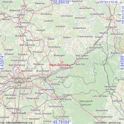
Hain-Gründau GPS coordinates[2]
50° 14' 34.224" North, 9° 8' 34.332" East
| Map corner | latitude | longitude |
|---|---|---|
| Upper-left | 50.69039°, | 8.43974° |
| Center: | 50.24284°, | 9.14287° |
| Lower-right: | 49.79104°, | 9.84599° |
| Map W x H: | 100×100 km | = 62.1×62.1mi |
| max Lat: | 55.01917° ⇑58.1% North |
| Hain-Gründau: | 50.24284° |
| min Lat: | ⇓41.9% South 47.40724° |
| min Long | Hain-Gründau | max Long |
| 5.92978° | 9.14287° | 14.98853° |
| W 36.7%⇐ | ⇒63.3% E |
Elevation
Elevation of Hain-Gründau is 149 m = 489 ft, and this is 100.1 m = 328 ft below average elevation for this country.
| Max E: |
1256 m = 4121 ft | 60.4% |
| Avg. | 249.1 m = 817 ft | |
| Hain-Gründau | 149 m = 489 ft | |
Min E: |
-5 m = -16 ft | 39.6% |
See also: Germany elevation on elevation.city.
Geographical zone
Hain-Gründau is located in North temperate zone (between Tropic of Cancer and the Arctic Circle). Distance of this North polar circle is 1814.7 km =1127.6 mi to North.| Distance of | km | miles | from Hain-Gründau |
|---|---|---|---|
| North Pole | 4420.6 | 2746.8 | to North |
| Arctic Circle | 1814.7 | 1127.6 | to North |
| Tropic Cancer | 2980.6 | 1852.1 | to South |
| Equator | 5586.5 | 3471.3 | to South |


Nearby cities:
15 places around Hain-Gründau: (largest is in red/bold)
• Altenstadt
15 km =9.3 mi,  289°
289°
• Bad Orb
14.7 km =9.1 mi,  96°
96°
• Birstein
16.3 km =10.1 mi,  43°
43°
• Büdingen
5.7 km =3.5 mi,  336°
336°
• Erlensee
14.7 km =9.1 mi,  232°
232°
• Geiselbach
13.8 km =8.6 mi,  163°
163°
• Gelnhausen
5.6 km =3.5 mi,  145°
145°
• Glauburg
13.1 km =8.1 mi,  308°
308°
• Hammersbach
11.7 km =7.3 mi,  255°
255°
• Kefenrod
12.3 km =7.6 mi,  23°
23°
• Langenselbold
10.4 km =6.5 mi,  224°
224°
• Nieder-Gründau
4.3 km =2.7 mi,  214°
214°
• Ortenberg
14 km =8.7 mi,  333°
333°
• Rodenbach
12.9 km =8 mi, 217°
• Wächtersbach
10.9 km =6.8 mi,  82°
82°
Sources, notices
• [Note1] Compared only with cities in Germany existing in our database
• [Src1] Map data: © OpenStreetMap contributors (CC-BY-SA)
• [Src2] Other city data from geonames.org with taken over terms of usage.
• [Src3] Geographical zone / Annual Mean Temperature by Robert A. Rohde @ Wikipedia
