Gelnhausen geodata
Gelnhausen (Hesse) is a seat of a third-order administrative division; located in Germany in Europe/Berlin (GMT+2) time zone. With population of 21,881 people, there are 690 cities with bigger population in this country. Compared to other cities in Germany, 58.9% of cities are located further ↑North; 62.5% of cities are located further →East and 61.9% of cities have higher elevation than Gelnhausen. Note1
Administrative division(s):
- Level 1: Hesse
- Level 2: Regierungsbezirk Darmstadt
- Level 3: Main-Kinzig-Kreis
- Level 4: Gelnhausen, Barbarossastadt


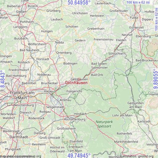
Gelnhausen GPS coordinates[2]
50° 12' 5.904" North, 9° 11' 14.712" East
| Map corner | latitude | longitude |
|---|---|---|
| Upper-left | 50.64958°, | 8.4843° |
| Center: | 50.20164°, | 9.18742° |
| Lower-right: | 49.74945°, | 9.89055° |
| Map W x H: | 100.1×100.1 km | = 62.2×62.2mi |
| max Lat: | 55.01917° ⇑58.9% North |
| Gelnhausen: | 50.20164° |
| min Lat: | ⇓41.1% South 47.40724° |
| min Long | Gelnhausen | max Long |
| 5.92978° | 9.18742° | 14.98853° |
| W 37.5%⇐ | ⇒62.5% E |
Elevation
Elevation of Gelnhausen is 139 m = 456 ft, and this is 110.1 m = 361 ft below average elevation for this country.
| Max E: |
1256 m = 4121 ft | 61.9% |
| Avg. | 249.1 m = 817 ft | |
| Gelnhausen | 139 m = 456 ft | |
Min E: |
-5 m = -16 ft | 38.1% |
See also: Germany elevation on elevation.city.
Geographical zone
Gelnhausen is located in North temperate zone (between Tropic of Cancer and the Arctic Circle). Distance of this North polar circle is 1819.3 km =1130.5 mi to North.| Distance of | km | miles | from Gelnhausen |
|---|---|---|---|
| North Pole | 4425.2 | 2749.7 | to North |
| Arctic Circle | 1819.3 | 1130.5 | to North |
| Tropic Cancer | 2976 | 1849.2 | to South |
| Equator | 5581.9 | 3468.4 | to South |


Nearby cities:
15 places around Gelnhausen: (largest is in red/bold)
• Alzenau in Unterfranken
15.3 km =9.5 mi,  214°
214°
• Bad Orb
11.8 km =7.3 mi,  75°
75°
• Bad Soden-Salmünster
15.2 km =9.4 mi,  57°
57°
• Büdingen
11.2 km =7 mi,  331°
331°
• Geiselbach
8.7 km =5.4 mi,  175°
175°
• Hain-Gründau
5.6 km =3.5 mi, 325°
• Hammersbach
14.6 km =9.1 mi,  276°
276°
• Kleinkahl
11 km =6.8 mi,  149°
149°
• Krombach
13.2 km =8.2 mi,  174°
174°
• Langenselbold
10.9 km =6.8 mi,  255°
255°
• Mömbris
14.8 km =9.2 mi,  186°
186°
• Nieder-Gründau
5.7 km =3.5 mi, 280°
• Rodenbach
12.4 km =7.7 mi,  242°
242°
• Schöllkrippen
13.6 km =8.5 mi,  161°
161°
• Wächtersbach
9.7 km =6 mi,  52°
52°
Sources, notices
• [Note1] Compared only with cities in Germany existing in our database
• [Src1] Map data: © OpenStreetMap contributors (CC-BY-SA)
• [Src2] Other city data from geonames.org with taken over terms of usage.
• [Src3] Geographical zone / Annual Mean Temperature by Robert A. Rohde @ Wikipedia
