Ortenberg geodata
Ortenberg (Hesse) is a populated place; located in Germany in Europe/Berlin (GMT+2) time zone. With population of 9,155 people, there are 1759 cities with bigger population in this country. Compared to other cities in Germany, 55.5% of cities are located further ↑North; 64.7% of cities are located further →East and 60.3% of cities have higher elevation than Ortenberg. Note1
Administrative division(s):
- Level 1: Hesse
- Level 2: Regierungsbezirk Darmstadt
- Level 3: Wetteraukreis
- Level 4: Ortenberg


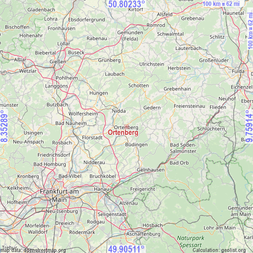
Ortenberg GPS coordinates[2]
50° 21' 21.024" North, 9° 3' 21.672" East
| Map corner | latitude | longitude |
|---|---|---|
| Upper-left | 50.80233°, | 8.35289° |
| Center: | 50.35584°, | 9.05602° |
| Lower-right: | 49.90511°, | 9.75914° |
| Map W x H: | 99.8×99.8 km | = 62×62mi |
| max Lat: | 55.01917° ⇑55.5% North |
| Ortenberg: | 50.35584° |
| min Lat: | ⇓44.5% South 47.40724° |
| min Long | Ortenberg | max Long |
| 5.92978° | 9.05602° | 14.98853° |
| W 35.3%⇐ | ⇒64.7% E |
Elevation
Elevation of Ortenberg is 150 m = 492 ft, and this is 99.1 m = 325 ft below average elevation for this country.
| Max E: |
1256 m = 4121 ft | 60.3% |
| Avg. | 249.1 m = 817 ft | |
| Ortenberg | 150 m = 492 ft | |
Min E: |
-5 m = -16 ft | 39.7% |
See also: Germany elevation on elevation.city.
Geographical zone
Ortenberg is located in North temperate zone (between Tropic of Cancer and the Arctic Circle). Distance of this North polar circle is 1802.1 km =1119.8 mi to North.| Distance of | km | miles | from Ortenberg |
|---|---|---|---|
| North Pole | 4408 | 2739 | to North |
| Arctic Circle | 1802.1 | 1119.8 | to North |
| Tropic Cancer | 2993.1 | 1859.8 | to South |
| Equator | 5599 | 3479.1 | to South |


Nearby cities:
15 places around Ortenberg: (largest is in red/bold)
• Altenstadt
11 km =6.8 mi,  226°
226°
• Berstadt
15.6 km =9.7 mi,  300°
300°
• Büdingen
8.3 km =5.2 mi,  151°
151°
• Echzell
12.6 km =7.8 mi,  286°
286°
• Florstadt
14.1 km =8.8 mi,  252°
252°
• Gedern
12.7 km =7.9 mi,  52°
52°
• Glauburg
5.9 km =3.7 mi,  222°
222°
• Hain-Gründau
14 km =8.7 mi, 153°
• Hammersbach
16.3 km =10.1 mi,  198°
198°
• Hirzenhain
7.4 km =4.6 mi, 48°
• Kefenrod
11.1 km =6.9 mi,  96°
96°
• Nidda
7.3 km =4.5 mi,  331°
331°
• Ranstadt
5.1 km =3.2 mi,  271°
271°
• Reichelsheim
12.9 km =8 mi, 270°
• Steinheim
13.5 km =8.4 mi,  316°
316°
Sources, notices
• [Note1] Compared only with cities in Germany existing in our database
• [Src1] Map data: © OpenStreetMap contributors (CC-BY-SA)
• [Src2] Other city data from geonames.org with taken over terms of usage.
• [Src3] Geographical zone / Annual Mean Temperature by Robert A. Rohde @ Wikipedia
