Karow geodata
Karow (Berlin) is a section of populated place; located in Germany in Europe/Berlin (GMT+2) time zone. With population of 18,817 people, there are 830 cities with bigger population in this country. Compared to other cities in Germany, 78.9% of cities are located further ↓South; 95.6% of cities are located further ←West and 77.3% of cities have higher elevation than Karow. Note1


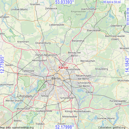
Karow GPS coordinates[2]
52° 36' 32.544" North, 13° 28' 52.212" East
| Map corner | latitude | longitude |
|---|---|---|
| Upper-left | 53.03393°, | 12.77805° |
| Center: | 52.60904°, | 13.48117° |
| Lower-right: | 52.17998°, | 14.1843° |
| Map W x H: | 95×94.9 km | = 59×59mi |
| max Lat: | 55.01917° ⇑21.1% North |
| Karow: | 52.60904° |
| min Lat: | ⇓78.9% South 47.40724° |
| min Long | Karow | max Long |
| 5.92978° | 13.48117° | 14.98853° |
| W 95.6%⇐ | ⇒4.4% E |
Elevation
Elevation of Karow is 55 m = 180 ft, and this is 194.1 m = 637 ft below average elevation for this country.
| Max E: |
1256 m = 4121 ft | 77.3% |
| Avg. | 249.1 m = 817 ft | |
| Karow | 55 m = 180 ft | |
Min E: |
-5 m = -16 ft | 22.7% |
See also: Germany elevation on elevation.city.
Geographical zone
Karow is located in North temperate zone (between Tropic of Cancer and the Arctic Circle). Distance of this North polar circle is 1551.6 km =964.1 mi to North.| Distance of | km | miles | from Karow |
|---|---|---|---|
| North Pole | 4157.5 | 2583.3 | to North |
| Arctic Circle | 1551.6 | 964.1 | to North |
| Tropic Cancer | 3243.7 | 2015.5 | to South |
| Equator | 5849.6 | 3634.8 | to South |


Nearby cities:
15 places around Karow: (largest is in red/bold)
• Alt-Hohenschönhausen
7.1 km =4.4 mi,  169°
169°
• Blankenburg
2.5 km =1.6 mi,  224°
224°
• Blankenfelde
6.2 km =3.9 mi,  279°
279°
• Buch
3 km =1.9 mi,  20°
20°
• Falkenberg
6.3 km =3.9 mi,  136°
136°
• Französisch Buchholz
3.5 km =2.2 mi,  257°
257°
• Heinersdorf
5.1 km =3.2 mi, 215°
• Malchow
2.9 km =1.8 mi,  177°
177°
• Neu-Hohenschönhausen
5.2 km =3.2 mi,  155°
155°
• Niederschönhausen
5.9 km =3.7 mi,  243°
243°
• Pankow
6.9 km =4.3 mi,  230°
230°
• Rosenthal
7.1 km =4.4 mi, 261°
• Stadtrandsiedlung Malchow
2.9 km =1.8 mi, 184°
• Wartenberg
4.4 km =2.7 mi,  148°
148°
• Weißensee
5.9 km =3.7 mi,  189°
189°
Sources, notices
• [Note1] Compared only with cities in Germany existing in our database
• [Src1] Map data: © OpenStreetMap contributors (CC-BY-SA)
• [Src2] Other city data from geonames.org with taken over terms of usage.
• [Src3] Geographical zone / Annual Mean Temperature by Robert A. Rohde @ Wikipedia
