Buch geodata
Buch (Berlin) is a section of populated place; located in Germany in Europe/Berlin (GMT+2) time zone. With population of 12,674 people, there are 1276 cities with bigger population in this country. Compared to other cities in Germany, 79.2% of cities are located further ↓South; 95.7% of cities are located further ←West and 76.7% of cities have higher elevation than Buch. Note1


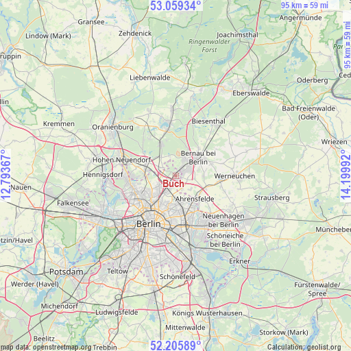
Buch GPS coordinates[2]
52° 38' 4.92" North, 13° 29' 48.444" East
| Map corner | latitude | longitude |
|---|---|---|
| Upper-left | 53.05934°, | 12.79367° |
| Center: | 52.6347°, | 13.49679° |
| Lower-right: | 52.20589°, | 14.19992° |
| Map W x H: | 94.9×94.9 km | = 59×59mi |
| max Lat: | 55.01917° ⇑20.8% North |
| Buch: | 52.6347° |
| min Lat: | ⇓79.2% South 47.40724° |
| min Long | Buch | max Long |
| 5.92978° | 13.49679° | 14.98853° |
| W 95.7%⇐ | ⇒4.3% E |
Elevation
Elevation of Buch is 57 m = 187 ft, and this is 192.1 m = 630 ft below average elevation for this country.
| Max E: |
1256 m = 4121 ft | 76.7% |
| Avg. | 249.1 m = 817 ft | |
| Buch | 57 m = 187 ft | |
Min E: |
-5 m = -16 ft | 23.3% |
See also: Germany elevation on elevation.city.
Geographical zone
Buch is located in North temperate zone (between Tropic of Cancer and the Arctic Circle). Distance of this North polar circle is 1548.7 km =962.3 mi to North.| Distance of | km | miles | from Buch |
|---|---|---|---|
| North Pole | 4154.6 | 2581.5 | to North |
| Arctic Circle | 1548.7 | 962.3 | to North |
| Tropic Cancer | 3246.5 | 2017.3 | to South |
| Equator | 5852.4 | 3636.5 | to South |


Nearby cities:
15 places around Buch: (largest is in red/bold)
• Ahrensfelde
8.6 km =5.3 mi,  139°
139°
• Bernau bei Berlin
7.9 km =4.9 mi,  50°
50°
• Blankenburg
5.4 km =3.4 mi,  211°
211°
• Blankenfelde
7.4 km =4.6 mi,  256°
256°
• Falkenberg
8.1 km =5 mi,  155°
155°
• Französisch Buchholz
5.8 km =3.6 mi,  231°
231°
• Heinersdorf
8.1 km =5 mi, 209°
• Karow
3 km =1.9 mi,  200°
200°
• Malchow
5.8 km =3.6 mi,  188°
188°
• Neu-Hohenschönhausen
7.6 km =4.7 mi,  171°
171°
• Niederschönhausen
8.4 km =5.2 mi, 228°
• Rosenthal
8.9 km =5.5 mi,  244°
244°
• Stadtrandsiedlung Malchow
5.9 km =3.7 mi, 192°
• Wartenberg
6.7 km =4.2 mi, 169°
• Weißensee
9 km =5.6 mi, 193°
Sources, notices
• [Note1] Compared only with cities in Germany existing in our database
• [Src1] Map data: © OpenStreetMap contributors (CC-BY-SA)
• [Src2] Other city data from geonames.org with taken over terms of usage.
• [Src3] Geographical zone / Annual Mean Temperature by Robert A. Rohde @ Wikipedia
