Pankow geodata
Pankow (Berlin) is a section of populated place; located in Germany in Europe/Berlin (GMT+2) time zone. With population of 57,113 people, there are 187 cities with bigger population in this country. Compared to other cities in Germany, 78.4% of cities are located further ↓South; 95.1% of cities are located further ←West and 79.9% of cities have higher elevation than Pankow. Note1


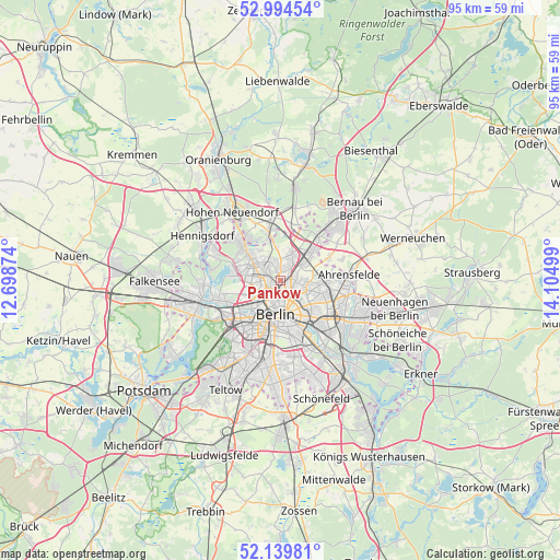
Pankow GPS coordinates[2]
52° 34' 9.336" North, 13° 24' 6.696" East
| Map corner | latitude | longitude |
|---|---|---|
| Upper-left | 52.99454°, | 12.69874° |
| Center: | 52.56926°, | 13.40186° |
| Lower-right: | 52.13981°, | 14.10499° |
| Map W x H: | 95×95 km | = 59×59mi |
| max Lat: | 55.01917° ⇑21.6% North |
| Pankow: | 52.56926° |
| min Lat: | ⇓78.4% South 47.40724° |
| min Long | Pankow | max Long |
| 5.92978° | 13.40186° | 14.98853° |
| W 95.1%⇐ | ⇒4.9% E |
Elevation
Elevation of Pankow is 47 m = 154 ft, and this is 202.1 m = 663 ft below average elevation for this country.
| Max E: |
1256 m = 4121 ft | 79.9% |
| Avg. | 249.1 m = 817 ft | |
| Pankow | 47 m = 154 ft | |
Min E: |
-5 m = -16 ft | 20.1% |
See also: Pankow elevation on elevation.city.
Geographical zone
Pankow is located in North temperate zone (between Tropic of Cancer and the Arctic Circle). Distance of this North polar circle is 1556 km =966.9 mi to North.| Distance of | km | miles | from Pankow |
|---|---|---|---|
| North Pole | 4161.9 | 2586.1 | to North |
| Arctic Circle | 1556 | 966.9 | to North |
| Tropic Cancer | 3239.2 | 2012.7 | to South |
| Equator | 5845.2 | 3632 | to South |


Nearby cities:
15 places around Pankow: (largest is in red/bold)
• Berlin
5 km =3.1 mi,  173°
173°
• Blankenburg
4.5 km =2.8 mi,  53°
53°
• Französisch Buchholz
4.2 km =2.6 mi,  27°
27°
• Gesundbrunnen
2.2 km =1.4 mi,  198°
198°
• Heinersdorf
2.4 km =1.5 mi,  83°
83°
• Mitte
5.5 km =3.4 mi,  177°
177°
• Märkisches Viertel
4.4 km =2.7 mi,  317°
317°
• Niederschönhausen
1.7 km =1.1 mi,  1°
1°
• Prenzlauer Berg
3.7 km =2.3 mi,  155°
155°
• Reinickendorf
4.6 km =2.9 mi,  266°
266°
• Rosenthal
3.8 km =2.4 mi,  334°
334°
• Stadtrandsiedlung Malchow
5.4 km =3.4 mi,  73°
73°
• Wedding
3.9 km =2.4 mi,  231°
231°
• Weißensee
4.6 km =2.9 mi,  108°
108°
• Wilhelmsruh
3 km =1.9 mi,  311°
311°
Sources, notices
• [Note1] Compared only with cities in Germany existing in our database
• [Src1] Map data: © OpenStreetMap contributors (CC-BY-SA)
• [Src2] Other city data from geonames.org with taken over terms of usage.
• [Src3] Geographical zone / Annual Mean Temperature by Robert A. Rohde @ Wikipedia
