Kaltennordheim geodata
Kaltennordheim (Thuringia) is a populated place; located in Germany in Europe/Berlin (GMT+2) time zone. With population of 1,896 people, there are 5209 cities with bigger population in this country. Compared to other cities in Germany, 50.2% of cities are located further ↓South; 52.6% of cities are located further ←West and 81% of cities have lower elevation than Kaltennordheim. Note1
Administrative division(s):
- Level 1: Thuringia
- Level 3: Landkreis Schmalkalden-Meiningen
- Level 4: Stadt Kaltennordheim


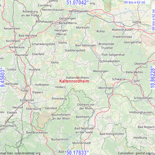
Kaltennordheim GPS coordinates[2]
50° 37' 35.364" North, 10° 9' 32.94" East
| Map corner | latitude | longitude |
|---|---|---|
| Upper-left | 51.07042°, | 9.45603° |
| Center: | 50.62649°, | 10.15915° |
| Lower-right: | 50.17833°, | 10.86228° |
| Map W x H: | 99.2×99.2 km | = 61.6×61.6mi |
| max Lat: | 55.01917° ⇑49.8% North |
| Kaltennordheim: | 50.62649° |
| min Lat: | ⇓50.2% South 47.40724° |
| min Long | Kaltennordheim | max Long |
| 5.92978° | 10.15915° | 14.98853° |
| W 52.6%⇐ | ⇒47.4% E |
Elevation
Elevation of Kaltennordheim is 440 m = 1444 ft, and this is 190.9 m = 626 ft above average elevation for this country.
| Max E: |
1256 m = 4121 ft | 19% |
| Kaltennordheim | 440 m 1444 ft | |
| Avg. | 249.1 m = 817 ft | |
Min E: |
-5 m = -16 ft | 81% |
See also: Germany elevation on elevation.city.
Geographical zone
Kaltennordheim is located in North temperate zone (between Tropic of Cancer and the Arctic Circle). Distance of this North polar circle is 1772 km =1101.1 mi to North.| Distance of | km | miles | from Kaltennordheim |
|---|---|---|---|
| North Pole | 4377.9 | 2720.3 | to North |
| Arctic Circle | 1772 | 1101.1 | to North |
| Tropic Cancer | 3023.2 | 1878.5 | to South |
| Equator | 5629.1 | 3497.8 | to South |


Nearby cities:
15 places around Kaltennordheim: (largest is in red/bold)
• Aschenhausen
4.1 km =2.5 mi,  135°
135°
• Empfertshausen
6.1 km =3.8 mi,  316°
316°
• Erbenhausen
6.7 km =4.2 mi,  185°
185°
• Friedelshausen
6.5 km =4 mi,  57°
57°
• Hümpfershausen
6.9 km =4.3 mi,  49°
49°
• Kaltenlengsfeld
2.8 km =1.7 mi, 55°
• Kaltensundheim
2.3 km =1.4 mi,  184°
184°
• Kaltenwestheim
3.5 km =2.2 mi,  238°
238°
• Klings
4 km =2.5 mi,  311°
311°
• Neidhartshausen
6.6 km =4.1 mi,  343°
343°
• Oberkatz
6 km =3.7 mi,  119°
119°
• Oberweid
7.8 km =4.8 mi, 239°
• Oepfershausen
6 km =3.7 mi,  74°
74°
• Unterkatz
6.9 km =4.3 mi,  96°
96°
• Unterweid
7.2 km =4.5 mi,  255°
255°
Sources, notices
• [Note1] Compared only with cities in Germany existing in our database
• [Src1] Map data: © OpenStreetMap contributors (CC-BY-SA)
• [Src2] Other city data from geonames.org with taken over terms of usage.
• [Src3] Geographical zone / Annual Mean Temperature by Robert A. Rohde @ Wikipedia
