Joachimsthal geodata
Joachimsthal (Brandenburg) is a populated place; located in Germany in Europe/Berlin (GMT+2) time zone. With population of 3,459 people, there are 3649 cities with bigger population in this country. Compared to other cities in Germany, 81.6% of cities are located further ↓South; 97% of cities are located further ←West and 73.4% of cities have higher elevation than Joachimsthal. Note1


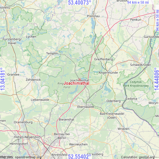
Joachimsthal GPS coordinates[2]
52° 58' 46.02" North, 13° 44' 41.748" East
| Map corner | latitude | longitude |
|---|---|---|
| Upper-left | 53.40073°, | 13.04181° |
| Center: | 52.97945°, | 13.74493° |
| Lower-right: | 52.55402°, | 14.44806° |
| Map W x H: | 94.1×94.1 km | = 58.5×58.5mi |
| max Lat: | 55.01917° ⇑18.4% North |
| Joachimsthal: | 52.97945° |
| min Lat: | ⇓81.6% South 47.40724° |
| min Long | Joachimsthal | max Long |
| 5.92978° | 13.74493° | 14.98853° |
| W 97%⇐ | ⇒3% E |
Elevation
Elevation of Joachimsthal is 70 m = 230 ft, and this is 179.1 m = 588 ft below average elevation for this country.
| Max E: |
1256 m = 4121 ft | 73.4% |
| Avg. | 249.1 m = 817 ft | |
| Joachimsthal | 70 m = 230 ft | |
Min E: |
-5 m = -16 ft | 26.6% |
See also: Germany elevation on elevation.city.
Geographical zone
Joachimsthal is located in North temperate zone (between Tropic of Cancer and the Arctic Circle). Distance of this North polar circle is 1510.4 km =938.5 mi to North.| Distance of | km | miles | from Joachimsthal |
|---|---|---|---|
| North Pole | 4116.3 | 2557.7 | to North |
| Arctic Circle | 1510.4 | 938.5 | to North |
| Tropic Cancer | 3284.8 | 2041.1 | to South |
| Equator | 5890.8 | 3660.4 | to South |


Nearby cities:
15 places around Joachimsthal: (largest is in red/bold)
• Althüttendorf
4.6 km =2.9 mi,  114°
114°
• Angermünde
17.5 km =10.9 mi,  76°
76°
• Britz
11.2 km =7 mi,  156°
156°
• Chorin
12.1 km =7.5 mi,  135°
135°
• Eberswalde
16.8 km =10.4 mi, 162°
• Friedrichswalde
6.1 km =3.8 mi,  335°
335°
• Gerswalde
21.2 km =13.2 mi,  0°
0°
• Golzow
8.7 km =5.4 mi,  150°
150°
• Hohenfinow
22.1 km =13.7 mi, 146°
• Liepe
19.9 km =12.4 mi,  130°
130°
• Marienwerder
18.1 km =11.2 mi,  212°
212°
• Melchow
22.8 km =14.2 mi,  186°
186°
• Milmersdorf
16.3 km =10.1 mi,  334°
334°
• Niederfinow
20.4 km =12.7 mi, 142°
• Templin
22.4 km =13.9 mi,  313°
313°
Sources, notices
• [Note1] Compared only with cities in Germany existing in our database
• [Src1] Map data: © OpenStreetMap contributors (CC-BY-SA)
• [Src2] Other city data from geonames.org with taken over terms of usage.
• [Src3] Geographical zone / Annual Mean Temperature by Robert A. Rohde @ Wikipedia
