Templin geodata
Templin (Brandenburg) is a populated place; located in Germany in Europe/Berlin (GMT+2) time zone. With population of 17,634 people, there are 902 cities with bigger population in this country. Compared to other cities in Germany, 82.4% of cities are located further ↓South; 95.8% of cities are located further ←West and 75.5% of cities have higher elevation than Templin. Note1


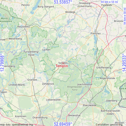
Templin GPS coordinates[2]
53° 7' 7.14" North, 13° 30' 7.92" East
| Map corner | latitude | longitude |
|---|---|---|
| Upper-left | 53.53857°, | 12.79908° |
| Center: | 53.11865°, | 13.5022° |
| Lower-right: | 52.69459°, | 14.20533° |
| Map W x H: | 93.8×93.8 km | = 58.3×58.3mi |
| max Lat: | 55.01917° ⇑17.6% North |
| Templin: | 53.11865° |
| min Lat: | ⇓82.4% South 47.40724° |
| min Long | Templin | max Long |
| 5.92978° | 13.5022° | 14.98853° |
| W 95.8%⇐ | ⇒4.2% E |
Elevation
Elevation of Templin is 61 m = 200 ft, and this is 188.1 m = 617 ft below average elevation for this country.
| Max E: |
1256 m = 4121 ft | 75.5% |
| Avg. | 249.1 m = 817 ft | |
| Templin | 61 m = 200 ft | |
Min E: |
-5 m = -16 ft | 24.5% |
See also: Germany elevation on elevation.city.
Geographical zone
Templin is located in North temperate zone (between Tropic of Cancer and the Arctic Circle). Distance of this North polar circle is 1494.9 km =928.9 mi to North.| Distance of | km | miles | from Templin |
|---|---|---|---|
| North Pole | 4100.8 | 2548.1 | to North |
| Arctic Circle | 1494.9 | 928.9 | to North |
| Tropic Cancer | 3300.3 | 2050.7 | to South |
| Equator | 5906.2 | 3669.9 | to South |


Nearby cities:
15 places around Templin: (largest is in red/bold)
• Althüttendorf
26.8 km =16.7 mi,  130°
130°
• Friedrichswalde
16.9 km =10.5 mi, 126°
• Fürstenberg
24.9 km =15.5 mi,  287°
287°
• Gerswalde
17.4 km =10.8 mi,  70°
70°
• Golzow
30.9 km =19.2 mi,  138°
138°
• Gransee
26.2 km =16.3 mi,  241°
241°
• Großwoltersdorf
27.5 km =17.1 mi,  257°
257°
• Joachimsthal
22.4 km =13.9 mi, 133°
• Liebenwalde
28.4 km =17.6 mi,  194°
194°
• Lychen
16.3 km =10.1 mi,  309°
309°
• Milmersdorf
9.3 km =5.8 mi,  94°
94°
• Mittenwalde
13.1 km =8.1 mi,  56°
56°
• Schönermark
28.4 km =17.6 mi, 244°
• Sonnenberg
29.8 km =18.5 mi,  248°
248°
• Zehdenick
19.3 km =12 mi,  216°
216°
Sources, notices
• [Note1] Compared only with cities in Germany existing in our database
• [Src1] Map data: © OpenStreetMap contributors (CC-BY-SA)
• [Src2] Other city data from geonames.org with taken over terms of usage.
• [Src3] Geographical zone / Annual Mean Temperature by Robert A. Rohde @ Wikipedia
