Hohenfinow geodata
Hohenfinow (Brandenburg) is a seat of a fourth-order administrative division; located in Germany in Europe/Berlin (GMT+2) time zone. With population of 536 people, there are 9155 cities with bigger population in this country. Compared to other cities in Germany, 80.5% of cities are located further ↓South; 97.7% of cities are located further ←West and 77.5% of cities have higher elevation than Hohenfinow. Note1


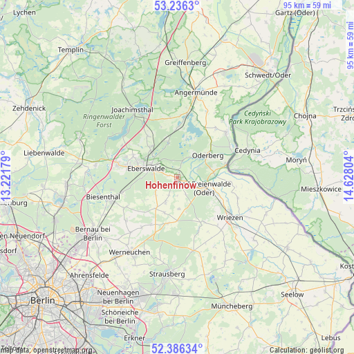
Hohenfinow GPS coordinates[2]
52° 48' 48.24" North, 13° 55' 29.676" East
| Map corner | latitude | longitude |
|---|---|---|
| Upper-left | 53.2363°, | 13.22179° |
| Center: | 52.8134°, | 13.92491° |
| Lower-right: | 52.38634°, | 14.62804° |
| Map W x H: | 94.5×94.5 km | = 58.7×58.7mi |
| max Lat: | 55.01917° ⇑19.5% North |
| Hohenfinow: | 52.8134° |
| min Lat: | ⇓80.5% South 47.40724° |
| min Long | Hohenfinow | max Long |
| 5.92978° | 13.92491° | 14.98853° |
| W 97.7%⇐ | ⇒2.3% E |
Elevation
Elevation of Hohenfinow is 54 m = 177 ft, and this is 195.1 m = 640 ft below average elevation for this country.
| Max E: |
1256 m = 4121 ft | 77.5% |
| Avg. | 249.1 m = 817 ft | |
| Hohenfinow | 54 m = 177 ft | |
Min E: |
-5 m = -16 ft | 22.5% |
See also: Germany elevation on elevation.city.
Geographical zone
Hohenfinow is located in North temperate zone (between Tropic of Cancer and the Arctic Circle). Distance of this North polar circle is 1528.9 km =950 mi to North.| Distance of | km | miles | from Hohenfinow |
|---|---|---|---|
| North Pole | 4134.8 | 2569.2 | to North |
| Arctic Circle | 1528.9 | 950 | to North |
| Tropic Cancer | 3266.4 | 2029.6 | to South |
| Equator | 5872.3 | 3648.9 | to South |


Nearby cities:
15 places around Hohenfinow: (largest is in red/bold)
• Althüttendorf
18.3 km =11.4 mi,  334°
334°
• Bad Freienwalde
7.7 km =4.8 mi,  112°
112°
• Biesenthal
19.6 km =12.2 mi,  254°
254°
• Britz
11.2 km =7 mi,  317°
317°
• Chorin
10.5 km =6.5 mi,  340°
340°
• Eberswalde
7.5 km =4.7 mi,  288°
288°
• Falkenberg
2.4 km =1.5 mi, 112°
• Golzow
13.3 km =8.3 mi, 324°
• Hohensaaten
16.1 km =10 mi,  65°
65°
• Liepe
6.2 km =3.9 mi,  28°
28°
• Melchow
15.3 km =9.5 mi, 254°
• Niederfinow
2.3 km =1.4 mi,  5°
5°
• Oderberg
9.9 km =6.2 mi,  54°
54°
• Werftpfuhl
19.2 km =11.9 mi,  207°
207°
• Wriezen
17.4 km =10.8 mi,  126°
126°
Sources, notices
• [Note1] Compared only with cities in Germany existing in our database
• [Src1] Map data: © OpenStreetMap contributors (CC-BY-SA)
• [Src2] Other city data from geonames.org with taken over terms of usage.
• [Src3] Geographical zone / Annual Mean Temperature by Robert A. Rohde @ Wikipedia
