Angermünde geodata
Angermünde (Brandenburg) is a populated place; located in Germany in Europe/Berlin (GMT+2) time zone. With population of 15,453 people, there are 1036 cities with bigger population in this country. Compared to other cities in Germany, 81.8% of cities are located further ↓South; 97.9% of cities are located further ←West and 79.9% of cities have higher elevation than Angermünde. Note1


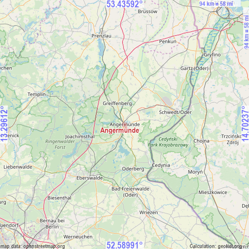
Angermünde GPS coordinates[2]
53° 0' 53.964" North, 13° 59' 57.264" East
| Map corner | latitude | longitude |
|---|---|---|
| Upper-left | 53.43592°, | 13.29612° |
| Center: | 53.01499°, | 13.99924° |
| Lower-right: | 52.58991°, | 14.70237° |
| Map W x H: | 94.1×94.1 km | = 58.5×58.5mi |
| max Lat: | 55.01917° ⇑18.2% North |
| Angermünde: | 53.01499° |
| min Lat: | ⇓81.8% South 47.40724° |
| min Long | Angermünde | max Long |
| 5.92978° | 13.99924° | 14.98853° |
| W 97.9%⇐ | ⇒2.1% E |
Elevation
Elevation of Angermünde is 47 m = 154 ft, and this is 202.1 m = 663 ft below average elevation for this country.
| Max E: |
1256 m = 4121 ft | 79.9% |
| Avg. | 249.1 m = 817 ft | |
| Angermünde | 47 m = 154 ft | |
Min E: |
-5 m = -16 ft | 20.1% |
See also: Germany elevation on elevation.city.
Geographical zone
Angermünde is located in North temperate zone (between Tropic of Cancer and the Arctic Circle). Distance of this North polar circle is 1506.5 km =936.1 mi to North.| Distance of | km | miles | from Angermünde |
|---|---|---|---|
| North Pole | 4112.3 | 2555.3 | to North |
| Arctic Circle | 1506.5 | 936.1 | to North |
| Tropic Cancer | 3288.8 | 2043.6 | to South |
| Equator | 5894.7 | 3662.8 | to South |


Nearby cities:
15 places around Angermünde: (largest is in red/bold)
• Althüttendorf
14.1 km =8.8 mi,  245°
245°
• Britz
19 km =11.8 mi,  221°
221°
• Chorin
15.2 km =9.4 mi,  214°
214°
• Friedrichswalde
19.6 km =12.2 mi,  274°
274°
• Golzow
17.2 km =10.7 mi,  227°
227°
• Hohensaaten
18.3 km =11.4 mi,  148°
148°
• Joachimsthal
17.5 km =10.9 mi,  256°
256°
• Liepe
17.1 km =10.6 mi,  186°
186°
• Meyenburg
16.2 km =10.1 mi,  78°
78°
• Oderberg
16.9 km =10.5 mi,  169°
169°
• Passow
16.2 km =10.1 mi,  28°
28°
• Pinnow
7.8 km =4.8 mi,  47°
47°
• Schwedt (Oder)
19.5 km =12.1 mi, 75°
• Schöneberg
9.6 km =6 mi,  94°
94°
• Zichow
19.6 km =12.2 mi,  7°
7°
Sources, notices
• [Note1] Compared only with cities in Germany existing in our database
• [Src1] Map data: © OpenStreetMap contributors (CC-BY-SA)
• [Src2] Other city data from geonames.org with taken over terms of usage.
• [Src3] Geographical zone / Annual Mean Temperature by Robert A. Rohde @ Wikipedia
