Ittlingen geodata
Ittlingen (Baden-Württemberg) is a seat of a fourth-order administrative division; located in Germany in Europe/Berlin (GMT+2) time zone. With population of 2,457 people, there are 4493 cities with bigger population in this country. Compared to other cities in Germany, 80.5% of cities are located further ↑North; 66.3% of cities are located further →East and 54% of cities have higher elevation than Ittlingen. Note1
Administrative division(s):
- Level 1: Baden-Württemberg
- Level 2: Regierungsbezirk Stuttgart
- Level 3: Landkreis Heilbronn
- Level 4: Ittlingen


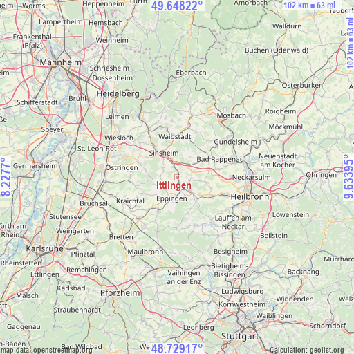
Ittlingen GPS coordinates[2]
49° 11' 26.988" North, 8° 55' 50.988" East
| Map corner | latitude | longitude |
|---|---|---|
| Upper-left | 49.64822°, | 8.2277° |
| Center: | 49.19083°, | 8.93083° |
| Lower-right: | 48.72917°, | 9.63395° |
| Map W x H: | 102.2×102.2 km | = 63.5×63.5mi |
| max Lat: | 55.01917° ⇑80.5% North |
| Ittlingen: | 49.19083° |
| min Lat: | ⇓19.5% South 47.40724° |
| min Long | Ittlingen | max Long |
| 5.92978° | 8.93083° | 14.98853° |
| W 33.7%⇐ | ⇒66.3% E |
Elevation
Elevation of Ittlingen is 197 m = 646 ft, and this is 52.1 m = 171 ft below average elevation for this country.
| Max E: |
1256 m = 4121 ft | 54% |
| Avg. | 249.1 m = 817 ft | |
| Ittlingen | 197 m = 646 ft | |
Min E: |
-5 m = -16 ft | 46% |
See also: Germany elevation on elevation.city.
Geographical zone
Ittlingen is located in North temperate zone (between Tropic of Cancer and the Arctic Circle). Distance of this North polar circle is 1931.7 km =1200.3 mi to North.| Distance of | km | miles | from Ittlingen |
|---|---|---|---|
| North Pole | 4537.6 | 2819.5 | to North |
| Arctic Circle | 1931.7 | 1200.3 | to North |
| Tropic Cancer | 2863.6 | 1779.4 | to South |
| Equator | 5469.5 | 3398.6 | to South |


Nearby cities:
15 places around Ittlingen: (largest is in red/bold)
• Bad Rappenau
13.5 km =8.4 mi,  66°
66°
• Balzfeld
13.5 km =8.4 mi,  310°
310°
• Eppingen
6.2 km =3.9 mi,  192°
192°
• Gemmingen
5.3 km =3.3 mi,  135°
135°
• Kirchardt
4.7 km =2.9 mi, 70°
• Kürnbach
14 km =8.7 mi,  206°
206°
• Leingarten
14.4 km =8.9 mi,  110°
110°
• Massenbachhausen
8.3 km =5.2 mi,  100°
100°
• Neckarbischofsheim
12 km =7.5 mi,  11°
11°
• Schwaigern
10.4 km =6.5 mi,  119°
119°
• Sinsheim
7.9 km =4.9 mi,  331°
331°
• Sulzfeld
11 km =6.8 mi, 209°
• Waibstadt
11.6 km =7.2 mi,  355°
355°
• Zaisenhausen
12.7 km =7.9 mi,  222°
222°
• Zuzenhausen
14.1 km =8.8 mi, 326°
Sources, notices
• [Note1] Compared only with cities in Germany existing in our database
• [Src1] Map data: © OpenStreetMap contributors (CC-BY-SA)
• [Src2] Other city data from geonames.org with taken over terms of usage.
• [Src3] Geographical zone / Annual Mean Temperature by Robert A. Rohde @ Wikipedia
