Zuzenhausen geodata
Zuzenhausen (Baden-Württemberg) is a seat of a fourth-order administrative division; located in Germany in Europe/Berlin (GMT+2) time zone. With population of 2,083 people, there are 4950 cities with bigger population in this country. Compared to other cities in Germany, 78.8% of cities are located further ↑North; 67.7% of cities are located further →East and 60.4% of cities have higher elevation than Zuzenhausen. Note1
Administrative division(s):
- Level 1: Baden-Württemberg
- Level 2: Karlsruhe Region
- Level 3: Rhein-Neckar-Kreis
- Level 4: Zuzenhausen


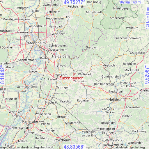
Zuzenhausen GPS coordinates[2]
49° 17' 46.896" North, 8° 49' 21.144" East
| Map corner | latitude | longitude |
|---|---|---|
| Upper-left | 49.75277°, | 8.11942° |
| Center: | 49.29636°, | 8.82254° |
| Lower-right: | 48.83568°, | 9.52567° |
| Map W x H: | 102×102 km | = 63.4×63.4mi |
| max Lat: | 55.01917° ⇑78.8% North |
| Zuzenhausen: | 49.29636° |
| min Lat: | ⇓21.2% South 47.40724° |
| min Long | Zuzenhausen | max Long |
| 5.92978° | 8.82254° | 14.98853° |
| W 32.3%⇐ | ⇒67.7% E |
Elevation
Elevation of Zuzenhausen is 149 m = 489 ft, and this is 100.1 m = 328 ft below average elevation for this country.
| Max E: |
1256 m = 4121 ft | 60.4% |
| Avg. | 249.1 m = 817 ft | |
| Zuzenhausen | 149 m = 489 ft | |
Min E: |
-5 m = -16 ft | 39.6% |
See also: Germany elevation on elevation.city.
Geographical zone
Zuzenhausen is located in North temperate zone (between Tropic of Cancer and the Arctic Circle). Distance of this North polar circle is 1919.9 km =1193 mi to North.| Distance of | km | miles | from Zuzenhausen |
|---|---|---|---|
| North Pole | 4525.8 | 2812.2 | to North |
| Arctic Circle | 1919.9 | 1193 | to North |
| Tropic Cancer | 2875.3 | 1786.6 | to South |
| Equator | 5481.2 | 3405.9 | to South |


Nearby cities:
15 places around Zuzenhausen: (largest is in red/bold)
• Balzfeld
3.9 km =2.4 mi,  218°
218°
• Bammental
7.3 km =4.5 mi,  334°
334°
• Dielheim
6.3 km =3.9 mi,  257°
257°
• Epfenbach
7.8 km =4.8 mi,  52°
52°
• Eschelbronn
4 km =2.5 mi, 50°
• Horrenberg
3.5 km =2.2 mi,  239°
239°
• Mauer
5.2 km =3.2 mi,  341°
341°
• Meckesheim
2.8 km =1.7 mi,  355°
355°
• Mühlhausen
8.7 km =5.4 mi,  232°
232°
• Neidenstein
5 km =3.1 mi,  63°
63°
• Sinsheim
6.3 km =3.9 mi,  139°
139°
• Spechbach
7.1 km =4.4 mi,  38°
38°
• Waibstadt
6.9 km =4.3 mi,  91°
91°
• Wiesenbach
7.4 km =4.6 mi,  349°
349°
• Wiesloch
9 km =5.6 mi,  269°
269°
Sources, notices
• [Note1] Compared only with cities in Germany existing in our database
• [Src1] Map data: © OpenStreetMap contributors (CC-BY-SA)
• [Src2] Other city data from geonames.org with taken over terms of usage.
• [Src3] Geographical zone / Annual Mean Temperature by Robert A. Rohde @ Wikipedia
