Ingenried geodata
Ingenried (Bavaria) is a seat of a fourth-order administrative division; located in Germany in Europe/Berlin (GMT+2) time zone. With population of 812 people, there are 7852 cities with bigger population in this country. Compared to other cities in Germany, 97.5% of cities are located further ↑North; 63.8% of cities are located further ←West and 99.2% of cities have lower elevation than Ingenried. Note1
Administrative division(s):
- Level 1: Bavaria
- Level 2: Upper Bavaria
- Level 3: Landkreis Weilheim-Schongau
- Level 4: Ingenried


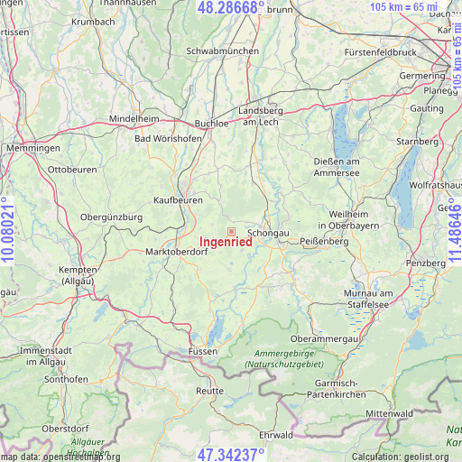
Ingenried GPS coordinates[2]
47° 49' 0.012" North, 10° 46' 59.988" East
| Map corner | latitude | longitude |
|---|---|---|
| Upper-left | 48.28668°, | 10.08021° |
| Center: | 47.81667°, | 10.78333° |
| Lower-right: | 47.34237°, | 11.48646° |
| Map W x H: | 105×105 km | = 65.2×65.2mi |
| max Lat: | 55.01917° ⇑97.5% North |
| Ingenried: | 47.81667° |
| min Lat: | ⇓2.5% South 47.40724° |
| min Long | Ingenried | max Long |
| 5.92978° | 10.78333° | 14.98853° |
| W 63.8%⇐ | ⇒36.2% E |
Elevation
Elevation of Ingenried is 803 m = 2635 ft, and this is 553.9 m = 1817 ft above average elevation for this country.
| Max E: |
1256 m = 4121 ft | 0.8% |
| Ingenried | 803 m 2635 ft | |
| Avg. | 249.1 m = 817 ft | |
Min E: |
-5 m = -16 ft | 99.2% |
See also: Germany elevation on elevation.city.
Geographical zone
Ingenried is located in North temperate zone (between Tropic of Cancer and the Arctic Circle). Distance of this North polar circle is 2084.5 km =1295.2 mi to North.| Distance of | km | miles | from Ingenried |
|---|---|---|---|
| North Pole | 4690.3 | 2914.4 | to North |
| Arctic Circle | 2084.5 | 1295.2 | to North |
| Tropic Cancer | 2710.8 | 1684.4 | to South |
| Equator | 5316.7 | 3303.6 | to South |


Nearby cities:
15 places around Ingenried: (largest is in red/bold)
• Altenstadt
6.9 km =4.3 mi,  83°
83°
• Bernbeuren
8.9 km =5.5 mi,  183°
183°
• Bidingen
4.5 km =2.8 mi,  288°
288°
• Biessenhofen
10.8 km =6.7 mi,  278°
278°
• Burggen
5.1 km =3.2 mi,  150°
150°
• Denklingen
12.2 km =7.6 mi,  24°
24°
• Hohenfurch
9.5 km =5.9 mi,  66°
66°
• Mauerstetten
12 km =7.5 mi,  315°
315°
• Osterzell
7.8 km =4.8 mi,  341°
341°
• Peiting
11.2 km =7 mi,  102°
102°
• Schongau
8.5 km =5.3 mi,  93°
93°
• Schwabbruck
4.1 km =2.5 mi, 76°
• Schwabsoien
4.2 km =2.6 mi,  63°
63°
• Stötten am Auerberg
11.2 km =7 mi,  219°
219°
• Stöttwang
8.9 km =5.5 mi,  326°
326°
Sources, notices
• [Note1] Compared only with cities in Germany existing in our database
• [Src1] Map data: © OpenStreetMap contributors (CC-BY-SA)
• [Src2] Other city data from geonames.org with taken over terms of usage.
• [Src3] Geographical zone / Annual Mean Temperature by Robert A. Rohde @ Wikipedia
