Biessenhofen geodata
Biessenhofen (Bavaria) is a seat of a fourth-order administrative division; located in Germany in Europe/Berlin (GMT+2) time zone. With population of 4,006 people, there are 3296 cities with bigger population in this country. Compared to other cities in Germany, 97.3% of cities are located further ↑North; 61.5% of cities are located further ←West and 97.8% of cities have lower elevation than Biessenhofen. Note1
Administrative division(s):
- Level 1: Bavaria
- Level 2: Swabia
- Level 3: Landkreis Ostallgäu
- Level 4: Biessenhofen


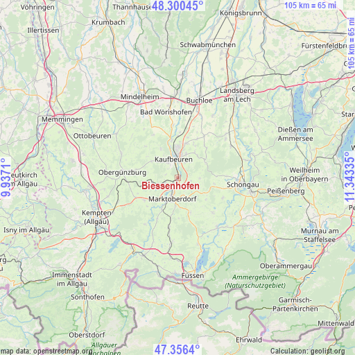
Biessenhofen GPS coordinates[2]
47° 49' 50.052" North, 10° 38' 24.792" East
| Map corner | latitude | longitude |
|---|---|---|
| Upper-left | 48.30045°, | 9.9371° |
| Center: | 47.83057°, | 10.64022° |
| Lower-right: | 47.3564°, | 11.34335° |
| Map W x H: | 105×105 km | = 65.2×65.2mi |
| max Lat: | 55.01917° ⇑97.3% North |
| Biessenhofen: | 47.83057° |
| min Lat: | ⇓2.7% South 47.40724° |
| min Long | Biessenhofen | max Long |
| 5.92978° | 10.64022° | 14.98853° |
| W 61.5%⇐ | ⇒38.5% E |
Elevation
Elevation of Biessenhofen is 699 m = 2293 ft, and this is 449.9 m = 1476 ft above average elevation for this country.
| Max E: |
1256 m = 4121 ft | 2.2% |
| Biessenhofen | 699 m 2293 ft | |
| Avg. | 249.1 m = 817 ft | |
Min E: |
-5 m = -16 ft | 97.8% |
See also: Germany elevation on elevation.city.
Geographical zone
Biessenhofen is located in North temperate zone (between Tropic of Cancer and the Arctic Circle). Distance of this North polar circle is 2082.9 km =1294.3 mi to North.| Distance of | km | miles | from Biessenhofen |
|---|---|---|---|
| North Pole | 4688.8 | 2913.5 | to North |
| Arctic Circle | 2082.9 | 1294.3 | to North |
| Tropic Cancer | 2712.3 | 1685.3 | to South |
| Equator | 5318.3 | 3304.6 | to South |


Nearby cities:
15 places around Biessenhofen: (largest is in red/bold)
• Aitrang
8.1 km =5 mi,  259°
259°
• Bidingen
6.4 km =4 mi,  90°
90°
• Friesenried
9.3 km =5.8 mi,  301°
301°
• Ingenried
10.8 km =6.7 mi,  98°
98°
• Irsee
10 km =6.2 mi,  329°
329°
• Kaufbeuren
5.9 km =3.7 mi,  346°
346°
• Marktoberdorf
5.9 km =3.7 mi,  196°
196°
• Mauerstetten
7.4 km =4.6 mi,  18°
18°
• Osterzell
10.1 km =6.3 mi,  54°
54°
• Pforzen
11.2 km =7 mi, 349°
• Ruderatshofen
4.5 km =2.8 mi,  250°
250°
• Stötten am Auerberg
10.8 km =6.7 mi,  160°
160°
• Stöttwang
8.2 km =5.1 mi,  44°
44°
• Unterthingau
12.1 km =7.5 mi,  237°
237°
• Westendorf
12.8 km =8 mi,  26°
26°
Sources, notices
• [Note1] Compared only with cities in Germany existing in our database
• [Src1] Map data: © OpenStreetMap contributors (CC-BY-SA)
• [Src2] Other city data from geonames.org with taken over terms of usage.
• [Src3] Geographical zone / Annual Mean Temperature by Robert A. Rohde @ Wikipedia
