Idar-Oberstein geodata
Idar-Oberstein (Rheinland-Pfalz) is a populated place; located in Germany in Europe/Berlin (GMT+2) time zone. With population of 31,610 people, there are 438 cities with bigger population in this country. Compared to other cities in Germany, 71.1% of cities are located further ↑North; 89.8% of cities are located further →East and 59.7% of cities have lower elevation than Idar-Oberstein. Note1
Administrative division(s):
- Level 1: Rheinland-Pfalz
- Level 3: Landkreis Birkenfeld
- Level 4: Idar-Oberstein


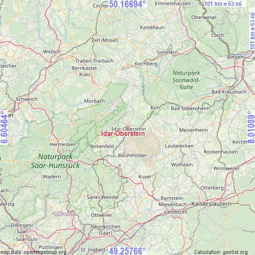
Idar-Oberstein GPS coordinates[2]
49° 42' 51.948" North, 7° 18' 27.936" East
| Map corner | latitude | longitude |
|---|---|---|
| Upper-left | 50.16694°, | 6.60464° |
| Center: | 49.71443°, | 7.30776° |
| Lower-right: | 49.25766°, | 8.01089° |
| Map W x H: | 101.1×101.1 km | = 62.8×62.8mi |
| max Lat: | 55.01917° ⇑71.1% North |
| Idar-Oberstein: | 49.71443° |
| min Lat: | ⇓28.9% South 47.40724° |
| min Long | Idar-Oberstein | max Long |
| 5.92978° | 7.30776° | 14.98853° |
| W 10.2%⇐ | ⇒89.8% E |
Elevation
Elevation of Idar-Oberstein is 288 m = 945 ft, and this is 38.9 m = 128 ft above average elevation for this country.
| Max E: |
1256 m = 4121 ft | 40.3% |
| Idar-Oberstein | 288 m 945 ft | |
| Avg. | 249.1 m = 817 ft | |
Min E: |
-5 m = -16 ft | 59.7% |
See also: Germany elevation on elevation.city.
Geographical zone
Idar-Oberstein is located in North temperate zone (between Tropic of Cancer and the Arctic Circle). Distance of this North polar circle is 1873.4 km =1164.1 mi to North.| Distance of | km | miles | from Idar-Oberstein |
|---|---|---|---|
| North Pole | 4479.3 | 2783.3 | to North |
| Arctic Circle | 1873.4 | 1164.1 | to North |
| Tropic Cancer | 2921.8 | 1815.5 | to South |
| Equator | 5527.7 | 3434.8 | to South |


Nearby cities:
15 places around Idar-Oberstein: (largest is in red/bold)
• Frauenberg
5.6 km =3.5 mi,  198°
198°
• Gerach
4.4 km =2.7 mi,  24°
24°
• Herborn
5.8 km =3.6 mi,  354°
354°
• Hettenrodt
4.8 km =3 mi,  306°
306°
• Hintertiefenbach
3.7 km =2.3 mi,  55°
55°
• Kirschweiler
5.7 km =3.5 mi, 313°
• Mackenrodt
4.2 km =2.6 mi,  273°
273°
• Niederbrombach
5.4 km =3.4 mi,  230°
230°
• Niederwörresbach
6.1 km =3.8 mi, 17°
• Oberbrombach
3.4 km =2.1 mi,  241°
241°
• Rötsweiler-Nockenthal
3 km =1.9 mi, 274°
• Siesbach
5.7 km =3.5 mi,  291°
291°
• Sonnenberg-Winnenberg
5.6 km =3.5 mi, 198°
• Veitsrodt
4.6 km =2.9 mi, 354°
• Vollmersbach
2.2 km =1.4 mi, 16°
Sources, notices
• [Note1] Compared only with cities in Germany existing in our database
• [Src1] Map data: © OpenStreetMap contributors (CC-BY-SA)
• [Src2] Other city data from geonames.org with taken over terms of usage.
• [Src3] Geographical zone / Annual Mean Temperature by Robert A. Rohde @ Wikipedia
