Gerach geodata
Gerach (Rheinland-Pfalz) is a seat of a fourth-order administrative division; located in Germany in Europe/Berlin (GMT+2) time zone. With population of 244 people, there are 10287 cities with bigger population in this country. Compared to other cities in Germany, 70.2% of cities are located further ↑North; 89.6% of cities are located further →East and 71.3% of cities have lower elevation than Gerach. Note1


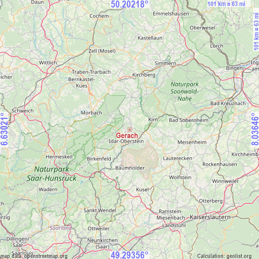
Gerach GPS coordinates[2]
49° 45' 0" North, 7° 19' 59.988" East
| Map corner | latitude | longitude |
|---|---|---|
| Upper-left | 50.20218°, | 6.63021° |
| Center: | 49.75°, | 7.33333° |
| Lower-right: | 49.29356°, | 8.03646° |
| Map W x H: | 101×101 km | = 62.8×62.8mi |
| max Lat: | 55.01917° ⇑70.2% North |
| Gerach: | 49.75° |
| min Lat: | ⇓29.8% South 47.40724° |
| min Long | Gerach | max Long |
| 5.92978° | 7.33333° | 14.98853° |
| W 10.4%⇐ | ⇒89.6% E |
Elevation
Elevation of Gerach is 368 m = 1207 ft, and this is 118.9 m = 390 ft above average elevation for this country.
| Max E: |
1256 m = 4121 ft | 28.7% |
| Gerach | 368 m 1207 ft | |
| Avg. | 249.1 m = 817 ft | |
Min E: |
-5 m = -16 ft | 71.3% |
See also: Germany elevation on elevation.city.
Geographical zone
Gerach is located in North temperate zone (between Tropic of Cancer and the Arctic Circle). Distance of this North polar circle is 1869.5 km =1161.7 mi to North.| Distance of | km | miles | from Gerach |
|---|---|---|---|
| North Pole | 4475.4 | 2780.9 | to North |
| Arctic Circle | 1869.5 | 1161.7 | to North |
| Tropic Cancer | 2925.8 | 1818 | to South |
| Equator | 5531.7 | 3437.2 | to South |


Nearby cities:
15 places around Gerach: (largest is in red/bold)
• Breitenthal
5.6 km =3.5 mi,  0°
0°
• Fischbach
5.1 km =3.2 mi,  111°
111°
• Herborn
3 km =1.9 mi,  307°
307°
• Herrstein
3.7 km =2.3 mi, 0°
• Hettenrodt
5.8 km =3.6 mi,  259°
259°
• Hintertiefenbach
2.2 km =1.4 mi,  147°
147°
• Idar-Oberstein
4.4 km =2.7 mi,  204°
204°
• Kirschweiler
6 km =3.7 mi,  270°
270°
• Mörschied
4.7 km =2.9 mi,  333°
333°
• Niederhosenbach
6.1 km =3.8 mi,  23°
23°
• Niederwörresbach
1.9 km =1.2 mi, 0°
• Oberwörresbach
3.9 km =2.4 mi,  342°
342°
• Rötsweiler-Nockenthal
6.1 km =3.8 mi,  232°
232°
• Veitsrodt
2.4 km =1.5 mi,  285°
285°
• Vollmersbach
2.2 km =1.4 mi,  212°
212°
Sources, notices
• [Note1] Compared only with cities in Germany existing in our database
• [Src1] Map data: © OpenStreetMap contributors (CC-BY-SA)
• [Src2] Other city data from geonames.org with taken over terms of usage.
• [Src3] Geographical zone / Annual Mean Temperature by Robert A. Rohde @ Wikipedia
