Hoyershausen geodata
Hoyershausen (Lower Saxony) is a seat of a fourth-order administrative division; located in Germany in Europe/Berlin (GMT+2) time zone. With population of 527 people, there are 9209 cities with bigger population in this country. Compared to other cities in Germany, 72.3% of cities are located further ↓South; 53.5% of cities are located further →East and 61.5% of cities have higher elevation than Hoyershausen. Note1
Administrative division(s):
- Level 1: Lower Saxony
- Level 3: Landkreis Hildesheim
- Level 4: Duingen, Flecken


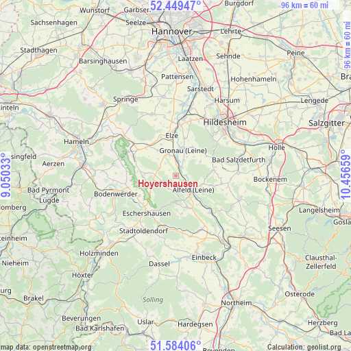
Hoyershausen GPS coordinates[2]
52° 1' 7.896" North, 9° 45' 12.456" East
| Map corner | latitude | longitude |
|---|---|---|
| Upper-left | 52.44947°, | 9.05033° |
| Center: | 52.01886°, | 9.75346° |
| Lower-right: | 51.58406°, | 10.45659° |
| Map W x H: | 96.2×96.2 km | = 59.8×59.8mi |
| max Lat: | 55.01917° ⇑27.7% North |
| Hoyershausen: | 52.01886° |
| min Lat: | ⇓72.3% South 47.40724° |
| min Long | Hoyershausen | max Long |
| 5.92978° | 9.75346° | 14.98853° |
| W 46.5%⇐ | ⇒53.5% E |
Elevation
Elevation of Hoyershausen is 142 m = 466 ft, and this is 107.1 m = 351 ft below average elevation for this country.
| Max E: |
1256 m = 4121 ft | 61.5% |
| Avg. | 249.1 m = 817 ft | |
| Hoyershausen | 142 m = 466 ft | |
Min E: |
-5 m = -16 ft | 38.5% |
See also: Germany elevation on elevation.city.
Geographical zone
Hoyershausen is located in North temperate zone (between Tropic of Cancer and the Arctic Circle). Distance of this North polar circle is 1617.2 km =1004.9 mi to North.| Distance of | km | miles | from Hoyershausen |
|---|---|---|---|
| North Pole | 4223.1 | 2624.1 | to North |
| Arctic Circle | 1617.2 | 1004.9 | to North |
| Tropic Cancer | 3178 | 1974.7 | to South |
| Equator | 5784 | 3594 | to South |


Nearby cities:
15 places around Hoyershausen: (largest is in red/bold)
• Alfeld
6 km =3.7 mi,  130°
130°
• Banteln
5.3 km =3.3 mi,  357°
357°
• Betheln
11 km =6.8 mi,  14°
14°
• Brüggen
3 km =1.9 mi,  28°
28°
• Coppengrave
4.2 km =2.6 mi,  199°
199°
• Delligsen
9.3 km =5.8 mi,  158°
158°
• Duingen
4.3 km =2.7 mi,  247°
247°
• Eberholzen
7.5 km =4.7 mi,  62°
62°
• Eime
6.6 km =4.1 mi,  340°
340°
• Gronau
7.5 km =4.7 mi, 12°
• Heinsen
7.9 km =4.9 mi,  308°
308°
• Marienhagen
5 km =3.1 mi,  294°
294°
• Rheden
4.9 km =3 mi, 27°
• Sibbesse
10.6 km =6.6 mi,  70°
70°
• Weenzen
6.2 km =3.9 mi, 285°
Sources, notices
• [Note1] Compared only with cities in Germany existing in our database
• [Src1] Map data: © OpenStreetMap contributors (CC-BY-SA)
• [Src2] Other city data from geonames.org with taken over terms of usage.
• [Src3] Geographical zone / Annual Mean Temperature by Robert A. Rohde @ Wikipedia
