Duingen geodata
Duingen (Lower Saxony) is a populated place; located in Germany in Europe/Berlin (GMT+2) time zone. With population of 3,116 people, there are 3905 cities with bigger population in this country. Compared to other cities in Germany, 72.2% of cities are located further ↓South; 54.4% of cities are located further →East and 53% of cities have higher elevation than Duingen. Note1
Administrative division(s):
- Level 1: Lower Saxony
- Level 3: Landkreis Hildesheim
- Level 4: Duingen, Flecken


Duingen GPS coordinates[2]
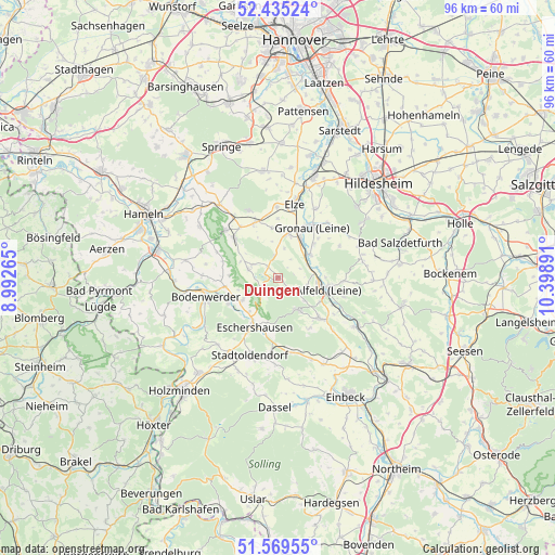
52° 0' 16.164" North, 9° 41' 44.808" East
| Map corner | latitude | longitude |
|---|---|---|
| Upper-left | 52.43524°, | 8.99265° |
| Center: | 52.00449°, | 9.69578° |
| Lower-right: | 51.56955°, | 10.39891° |
| Map W x H: | 96.3×96.3 km | = 59.8×59.8mi |
| max Lat: | 55.01917° ⇑27.8% North |
| Duingen: | 52.00449° |
| min Lat: | ⇓72.2% South 47.40724° |
| min Long | Duingen | max Long |
| 5.92978° | 9.69578° | 14.98853° |
| W 45.6%⇐ | ⇒54.4% E |
Elevation
Elevation of Duingen is 204 m = 669 ft, and this is 45.1 m = 148 ft below average elevation for this country.
| Max E: |
1256 m = 4121 ft | 53% |
| Avg. | 249.1 m = 817 ft | |
| Duingen | 204 m = 669 ft | |
Min E: |
-5 m = -16 ft | 47% |
See also: Germany elevation on elevation.city.
Geographical zone
Duingen is located in North temperate zone (between Tropic of Cancer and the Arctic Circle). Distance of this North polar circle is 1618.8 km =1005.9 mi to North.| Distance of | km | miles | from Duingen |
|---|---|---|---|
| North Pole | 4224.7 | 2625.1 | to North |
| Arctic Circle | 1618.8 | 1005.9 | to North |
| Tropic Cancer | 3176.4 | 1973.7 | to South |
| Equator | 5782.4 | 3593 | to South |


Nearby cities:
15 places around Duingen: (largest is in red/bold)
• Alfeld
8.8 km =5.5 mi,  105°
105°
• Banteln
7.8 km =4.8 mi,  28°
28°
• Brüggen
6.8 km =4.2 mi,  51°
51°
• Coppengrave
3.5 km =2.2 mi,  132°
132°
• Dielmissen
7.2 km =4.5 mi,  238°
238°
• Eime
8 km =5 mi,  12°
12°
• Halle
9.1 km =5.7 mi,  260°
260°
• Heinsen
6.8 km =4.2 mi,  340°
340°
• Holzen
8.2 km =5.1 mi,  194°
194°
• Hoyershausen
4.3 km =2.7 mi,  67°
67°
• Kirchbrak
9.3 km =5.8 mi, 242°
• Lüerdissen
7.5 km =4.7 mi,  220°
220°
• Marienhagen
3.7 km =2.3 mi,  350°
350°
• Rheden
8.6 km =5.3 mi, 46°
• Weenzen
3.8 km =2.4 mi,  328°
328°
Sources, notices
• [Note1] Compared only with cities in Germany existing in our database
• [Src1] Map data: © OpenStreetMap contributors (CC-BY-SA)
• [Src2] Other city data from geonames.org with taken over terms of usage.
• [Src3] Geographical zone / Annual Mean Temperature by Robert A. Rohde @ Wikipedia
