Gronau geodata
Gronau (Lower Saxony) is a populated place; located in Germany in Europe/Berlin (GMT+2) time zone. With population of 5,444 people, there are 2648 cities with bigger population in this country. Compared to other cities in Germany, 72.9% of cities are located further ↓South; 53.1% of cities are located further →East and 71.5% of cities have higher elevation than Gronau. Note1
Administrative division(s):
- Level 1: Lower Saxony
- Level 3: Landkreis Hildesheim
- Level 4: Gronau (Leine)


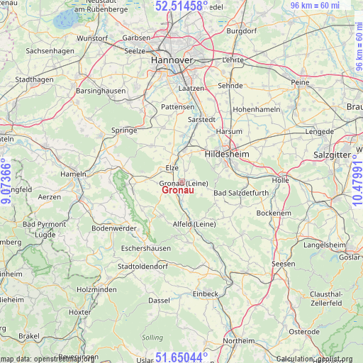
Gronau GPS coordinates[2]
52° 5' 4.56" North, 9° 46' 36.408" East
| Map corner | latitude | longitude |
|---|---|---|
| Upper-left | 52.51458°, | 9.07366° |
| Center: | 52.0846°, | 9.77678° |
| Lower-right: | 51.65044°, | 10.47991° |
| Map W x H: | 96.1×96.1 km | = 59.7×59.7mi |
| max Lat: | 55.01917° ⇑27.1% North |
| Gronau: | 52.0846° |
| min Lat: | ⇓72.9% South 47.40724° |
| min Long | Gronau | max Long |
| 5.92978° | 9.77678° | 14.98853° |
| W 46.9%⇐ | ⇒53.1% E |
Elevation
Elevation of Gronau is 81 m = 266 ft, and this is 168.1 m = 552 ft below average elevation for this country.
| Max E: |
1256 m = 4121 ft | 71.5% |
| Avg. | 249.1 m = 817 ft | |
| Gronau | 81 m = 266 ft | |
Min E: |
-5 m = -16 ft | 28.5% |
See also: Germany elevation on elevation.city.
Geographical zone
Gronau is located in North temperate zone (between Tropic of Cancer and the Arctic Circle). Distance of this North polar circle is 1609.9 km =1000.3 mi to North.| Distance of | km | miles | from Gronau |
|---|---|---|---|
| North Pole | 4215.8 | 2619.6 | to North |
| Arctic Circle | 1609.9 | 1000.3 | to North |
| Tropic Cancer | 3185.3 | 1979.3 | to South |
| Equator | 5791.3 | 3598.5 | to South |


Nearby cities:
15 places around Gronau: (largest is in red/bold)
• Banteln
2.7 km =1.7 mi,  222°
222°
• Betheln
3.5 km =2.2 mi,  19°
19°
• Brüggen
4.7 km =2.9 mi,  181°
181°
• Diekholzen
9.8 km =6.1 mi,  82°
82°
• Eberholzen
6.3 km =3.9 mi,  127°
127°
• Eime
4 km =2.5 mi,  253°
253°
• Elze
5.1 km =3.2 mi,  326°
326°
• Heinsen
8.1 km =5 mi, 252°
• Heyersum
8.4 km =5.2 mi, 16°
• Hoyershausen
7.5 km =4.7 mi,  192°
192°
• Marienhagen
8.1 km =5 mi,  229°
229°
• Nordstemmen
8.6 km =5.3 mi,  3°
3°
• Rheden
3.1 km =1.9 mi,  166°
166°
• Sibbesse
9.3 km =5.8 mi,  114°
114°
• Weenzen
9.4 km =5.8 mi, 232°
Sources, notices
• [Note1] Compared only with cities in Germany existing in our database
• [Src1] Map data: © OpenStreetMap contributors (CC-BY-SA)
• [Src2] Other city data from geonames.org with taken over terms of usage.
• [Src3] Geographical zone / Annual Mean Temperature by Robert A. Rohde @ Wikipedia
