Betheln geodata
Betheln (Lower Saxony) is a seat of a fourth-order administrative division; located in Germany in Europe/Berlin (GMT+2) time zone. With population of 1,093 people, there are 6866 cities with bigger population in this country. Compared to other cities in Germany, 73.1% of cities are located further ↓South; 52.9% of cities are located further →East and 67.4% of cities have higher elevation than Betheln. Note1
Administrative division(s):
- Level 1: Lower Saxony
- Level 3: Landkreis Hildesheim
- Level 4: Gronau (Leine)


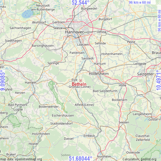
Betheln GPS coordinates[2]
52° 6' 51.516" North, 9° 47' 38.292" East
| Map corner | latitude | longitude |
|---|---|---|
| Upper-left | 52.544°, | 9.09085° |
| Center: | 52.11431°, | 9.79397° |
| Lower-right: | 51.68044°, | 10.4971° |
| Map W x H: | 96×96 km | = 59.7×59.7mi |
| max Lat: | 55.01917° ⇑26.9% North |
| Betheln: | 52.11431° |
| min Lat: | ⇓73.1% South 47.40724° |
| min Long | Betheln | max Long |
| 5.92978° | 9.79397° | 14.98853° |
| W 47.1%⇐ | ⇒52.9% E |
Elevation
Elevation of Betheln is 105 m = 344 ft, and this is 144.1 m = 473 ft below average elevation for this country.
| Max E: |
1256 m = 4121 ft | 67.4% |
| Avg. | 249.1 m = 817 ft | |
| Betheln | 105 m = 344 ft | |
Min E: |
-5 m = -16 ft | 32.6% |
See also: Germany elevation on elevation.city.
Geographical zone
Betheln is located in North temperate zone (between Tropic of Cancer and the Arctic Circle). Distance of this North polar circle is 1606.6 km =998.3 mi to North.| Distance of | km | miles | from Betheln |
|---|---|---|---|
| North Pole | 4212.5 | 2617.5 | to North |
| Arctic Circle | 1606.6 | 998.3 | to North |
| Tropic Cancer | 3188.6 | 1981.3 | to South |
| Equator | 5794.6 | 3600.6 | to South |


Nearby cities:
15 places around Betheln: (largest is in red/bold)
• Banteln
6.1 km =3.8 mi,  209°
209°
• Brüggen
8.1 km =5 mi,  189°
189°
• Diekholzen
8.8 km =5.5 mi,  103°
103°
• Eberholzen
8.1 km =5 mi,  151°
151°
• Eime
6.7 km =4.2 mi,  228°
228°
• Elze
4.1 km =2.5 mi,  283°
283°
• Gronau
3.5 km =2.2 mi,  199°
199°
• Heinsen
10.6 km =6.6 mi,  237°
237°
• Heyersum
4.9 km =3 mi,  15°
15°
• Hoyershausen
11 km =6.8 mi, 194°
• Marienhagen
11.3 km =7 mi,  220°
220°
• Nordstemmen
5.3 km =3.3 mi,  352°
352°
• Rheden
6.3 km =3.9 mi,  184°
184°
• Sibbesse
10.2 km =6.3 mi,  134°
134°
• Westfeld
11 km =6.8 mi, 130°
Sources, notices
• [Note1] Compared only with cities in Germany existing in our database
• [Src1] Map data: © OpenStreetMap contributors (CC-BY-SA)
• [Src2] Other city data from geonames.org with taken over terms of usage.
• [Src3] Geographical zone / Annual Mean Temperature by Robert A. Rohde @ Wikipedia
