Höringen geodata
Höringen (Rheinland-Pfalz) is a seat of a fourth-order administrative division; located in Germany in Europe/Berlin (GMT+2) time zone. With population of 750 people, there are 8099 cities with bigger population in this country. Compared to other cities in Germany, 74.7% of cities are located further ↑North; 81.1% of cities are located further →East and 61.3% of cities have lower elevation than Höringen. Note1


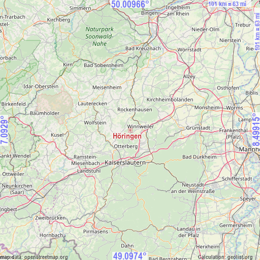
Höringen GPS coordinates[2]
49° 33' 20.376" North, 7° 47' 45.672" East
| Map corner | latitude | longitude |
|---|---|---|
| Upper-left | 50.00966°, | 7.0929° |
| Center: | 49.55566°, | 7.79602° |
| Lower-right: | 49.0974°, | 8.49915° |
| Map W x H: | 101.4×101.4 km | = 63×63mi |
| max Lat: | 55.01917° ⇑74.7% North |
| Höringen: | 49.55566° |
| min Lat: | ⇓25.3% South 47.40724° |
| min Long | Höringen | max Long |
| 5.92978° | 7.79602° | 14.98853° |
| W 18.9%⇐ | ⇒81.1% E |
Elevation
Elevation of Höringen is 298 m = 978 ft, and this is 48.9 m = 160 ft above average elevation for this country.
| Max E: |
1256 m = 4121 ft | 38.7% |
| Höringen | 298 m 978 ft | |
| Avg. | 249.1 m = 817 ft | |
Min E: |
-5 m = -16 ft | 61.3% |
See also: Germany elevation on elevation.city.
Geographical zone
Höringen is located in North temperate zone (between Tropic of Cancer and the Arctic Circle). Distance of this North polar circle is 1891.1 km =1175.1 mi to North.| Distance of | km | miles | from Höringen |
|---|---|---|---|
| North Pole | 4497 | 2794.3 | to North |
| Arctic Circle | 1891.1 | 1175.1 | to North |
| Tropic Cancer | 2904.2 | 1804.6 | to South |
| Equator | 5510.1 | 3423.8 | to South |


Nearby cities:
15 places around Höringen: (largest is in red/bold)
• Gehrweiler
3.7 km =2.3 mi,  325°
325°
• Gundersweiler
5 km =3.1 mi,  349°
349°
• Heiligenmoschel
2.2 km =1.4 mi,  253°
253°
• Imsbach
7 km =4.3 mi,  63°
63°
• Imsweiler
4.9 km =3 mi,  3°
3°
• Lohnsfeld
3.9 km =2.4 mi,  99°
99°
• Münchweiler an der Alsenz
6.3 km =3.9 mi, 95°
• Otterberg
6.1 km =3.8 mi,  197°
197°
• Reichsthal
6.7 km =4.2 mi,  317°
317°
• Schallodenbach
5.8 km =3.6 mi,  263°
263°
• Schneckenhausen
4.2 km =2.6 mi,  242°
242°
• Schweisweiler
3.4 km =2.1 mi,  25°
25°
• Sembach
7.1 km =4.4 mi,  133°
133°
• Wartenberg-Rohrbach
5.1 km =3.2 mi, 127°
• Winnweiler
4.1 km =2.5 mi,  72°
72°
Sources, notices
• [Note1] Compared only with cities in Germany existing in our database
• [Src1] Map data: © OpenStreetMap contributors (CC-BY-SA)
• [Src2] Other city data from geonames.org with taken over terms of usage.
• [Src3] Geographical zone / Annual Mean Temperature by Robert A. Rohde @ Wikipedia
