Lohnsfeld geodata
Lohnsfeld (Rheinland-Pfalz) is a seat of a fourth-order administrative division; located in Germany in Europe/Berlin (GMT+2) time zone. With population of 999 people, there are 7188 cities with bigger population in this country. Compared to other cities in Germany, 74.8% of cities are located further ↑North; 80.1% of cities are located further →East and 56.3% of cities have lower elevation than Lohnsfeld. Note1


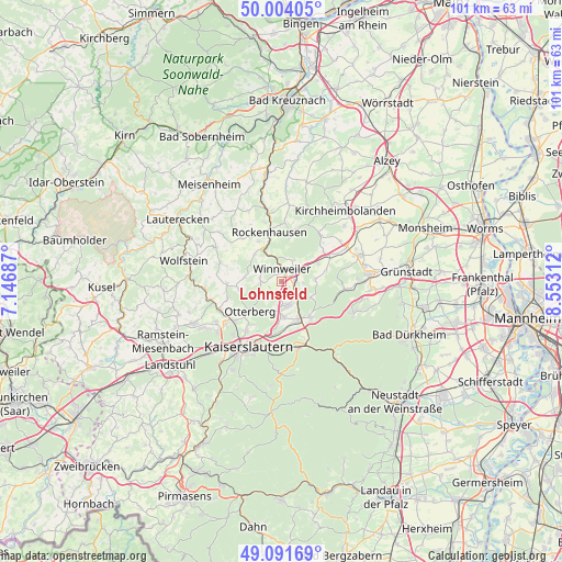
Lohnsfeld GPS coordinates[2]
49° 33' 0" North, 7° 51' 0" East
| Map corner | latitude | longitude |
|---|---|---|
| Upper-left | 50.00405°, | 7.14687° |
| Center: | 49.55°, | 7.85° |
| Lower-right: | 49.09169°, | 8.55312° |
| Map W x H: | 101.4×101.4 km | = 63×63mi |
| max Lat: | 55.01917° ⇑74.8% North |
| Lohnsfeld: | 49.55° |
| min Lat: | ⇓25.2% South 47.40724° |
| min Long | Lohnsfeld | max Long |
| 5.92978° | 7.85° | 14.98853° |
| W 19.9%⇐ | ⇒80.1% E |
Elevation
Elevation of Lohnsfeld is 268 m = 879 ft, and this is 18.9 m = 62 ft above average elevation for this country.
| Max E: |
1256 m = 4121 ft | 43.7% |
| Lohnsfeld | 268 m 879 ft | |
| Avg. | 249.1 m = 817 ft | |
Min E: |
-5 m = -16 ft | 56.3% |
See also: Germany elevation on elevation.city.
Geographical zone
Lohnsfeld is located in North temperate zone (between Tropic of Cancer and the Arctic Circle). Distance of this North polar circle is 1891.7 km =1175.4 mi to North.| Distance of | km | miles | from Lohnsfeld |
|---|---|---|---|
| North Pole | 4497.6 | 2794.7 | to North |
| Arctic Circle | 1891.7 | 1175.4 | to North |
| Tropic Cancer | 2903.5 | 1804.2 | to South |
| Equator | 5509.4 | 3423.4 | to South |


Nearby cities:
15 places around Lohnsfeld: (largest is in red/bold)
• Falkenstein
6.1 km =3.8 mi,  23°
23°
• Gehrweiler
7.1 km =4.4 mi,  301°
301°
• Gonbach
3.6 km =2.2 mi,  90°
90°
• Heiligenmoschel
6 km =3.7 mi,  270°
270°
• Höringen
3.9 km =2.4 mi,  279°
279°
• Imsbach
4.4 km =2.7 mi,  32°
32°
• Imsweiler
6.6 km =4.1 mi,  327°
327°
• Mehlingen
6.5 km =4 mi,  177°
177°
• Münchweiler an der Alsenz
2.4 km =1.5 mi, 90°
• Neuhemsbach
6.1 km =3.8 mi,  127°
127°
• Schweisweiler
4.4 km =2.7 mi, 327°
• Sembach
4.4 km =2.7 mi,  164°
164°
• Sippersfeld
6 km =3.7 mi, 90°
• Wartenberg-Rohrbach
2.5 km =1.6 mi, 175°
• Winnweiler
1.9 km =1.2 mi,  0°
0°
Sources, notices
• [Note1] Compared only with cities in Germany existing in our database
• [Src1] Map data: © OpenStreetMap contributors (CC-BY-SA)
• [Src2] Other city data from geonames.org with taken over terms of usage.
• [Src3] Geographical zone / Annual Mean Temperature by Robert A. Rohde @ Wikipedia
