Schweisweiler geodata
Schweisweiler (Rheinland-Pfalz) is a seat of a fourth-order administrative division; located in Germany in Europe/Berlin (GMT+2) time zone. With population of 370 people, there are 9788 cities with bigger population in this country. Compared to other cities in Germany, 74.2% of cities are located further ↑North; 80.7% of cities are located further →East and 59.1% of cities have lower elevation than Schweisweiler. Note1
Administrative division(s):
- Level 1: Rheinland-Pfalz
- Level 3: Donnersbergkreis
- Level 4: Schweisweiler


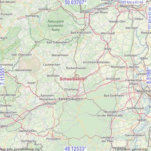
Schweisweiler GPS coordinates[2]
49° 34' 59.988" North, 7° 49' 0.012" East
| Map corner | latitude | longitude |
|---|---|---|
| Upper-left | 50.03707°, | 7.11355° |
| Center: | 49.58333°, | 7.81667° |
| Lower-right: | 49.12533°, | 8.5198° |
| Map W x H: | 101.4×101.4 km | = 63×63mi |
| max Lat: | 55.01917° ⇑74.2% North |
| Schweisweiler: | 49.58333° |
| min Lat: | ⇓25.8% South 47.40724° |
| min Long | Schweisweiler | max Long |
| 5.92978° | 7.81667° | 14.98853° |
| W 19.3%⇐ | ⇒80.7% E |
Elevation
Elevation of Schweisweiler is 284 m = 932 ft, and this is 34.9 m = 115 ft above average elevation for this country.
| Max E: |
1256 m = 4121 ft | 40.9% |
| Schweisweiler | 284 m 932 ft | |
| Avg. | 249.1 m = 817 ft | |
Min E: |
-5 m = -16 ft | 59.1% |
See also: Germany elevation on elevation.city.
Geographical zone
Schweisweiler is located in North temperate zone (between Tropic of Cancer and the Arctic Circle). Distance of this North polar circle is 1888 km =1173.1 mi to North.| Distance of | km | miles | from Schweisweiler |
|---|---|---|---|
| North Pole | 4493.9 | 2792.4 | to North |
| Arctic Circle | 1888 | 1173.1 | to North |
| Tropic Cancer | 2907.2 | 1806.4 | to South |
| Equator | 5513.1 | 3425.7 | to South |


Nearby cities:
15 places around Schweisweiler: (largest is in red/bold)
• Dörrmoschel
6.1 km =3.8 mi,  307°
307°
• Falkenstein
5.1 km =3.2 mi,  68°
68°
• Gehrweiler
3.6 km =2.2 mi,  270°
270°
• Gundersweiler
3 km =1.9 mi, 307°
• Heiligenmoschel
5.2 km =3.2 mi,  224°
224°
• Höringen
3.4 km =2.1 mi,  205°
205°
• Imsbach
4.8 km =3 mi,  90°
90°
• Imsweiler
2.2 km =1.4 mi,  327°
327°
• Lohnsfeld
4.4 km =2.7 mi,  147°
147°
• Münchweiler an der Alsenz
6.1 km =3.8 mi,  127°
127°
• Reichsthal
6.3 km =3.9 mi,  287°
287°
• Rockenhausen
5.2 km =3.2 mi,  3°
3°
• Schönborn
6.6 km =4.1 mi, 327°
• Wartenberg-Rohrbach
6.7 km =4.2 mi,  157°
157°
• Winnweiler
3 km =1.9 mi, 127°
Sources, notices
• [Note1] Compared only with cities in Germany existing in our database
• [Src1] Map data: © OpenStreetMap contributors (CC-BY-SA)
• [Src2] Other city data from geonames.org with taken over terms of usage.
• [Src3] Geographical zone / Annual Mean Temperature by Robert A. Rohde @ Wikipedia
