Hoort geodata
Hoort (Mecklenburg-Vorpommern) is a populated place; located in Germany in Europe/Berlin (GMT+2) time zone. With population of 623 people, there are 8698 cities with bigger population in this country. Compared to other cities in Germany, 85.4% of cities are located further ↓South; 72.1% of cities are located further ←West and 82.8% of cities have higher elevation than Hoort. Note1
Administrative division(s):
- Level 1: Mecklenburg-Vorpommern
- Level 3: Ludwigslust-Parchim
- Level 4: Hoort


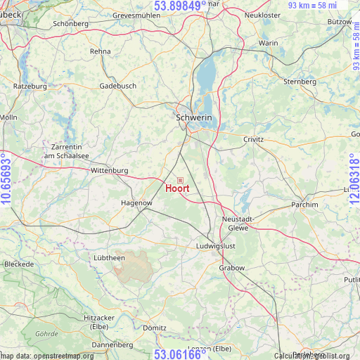
Hoort GPS coordinates[2]
53° 28' 55.704" North, 11° 21' 36.18" East
| Map corner | latitude | longitude |
|---|---|---|
| Upper-left | 53.89849°, | 10.65693° |
| Center: | 53.48214°, | 11.36005° |
| Lower-right: | 53.06166°, | 12.06318° |
| Map W x H: | 93×93 km | = 57.8×57.8mi |
| max Lat: | 55.01917° ⇑14.6% North |
| Hoort: | 53.48214° |
| min Lat: | ⇓85.4% South 47.40724° |
| min Long | Hoort | max Long |
| 5.92978° | 11.36005° | 14.98853° |
| W 72.1%⇐ | ⇒27.9% E |
Elevation
Elevation of Hoort is 40 m = 131 ft, and this is 209.1 m = 686 ft below average elevation for this country.
| Max E: |
1256 m = 4121 ft | 82.8% |
| Avg. | 249.1 m = 817 ft | |
| Hoort | 40 m = 131 ft | |
Min E: |
-5 m = -16 ft | 17.2% |
See also: Germany elevation on elevation.city.
Geographical zone
Hoort is located in North temperate zone (between Tropic of Cancer and the Arctic Circle). Distance of this North polar circle is 1454.5 km =903.8 mi to North.| Distance of | km | miles | from Hoort |
|---|---|---|---|
| North Pole | 4060.4 | 2523 | to North |
| Arctic Circle | 1454.5 | 903.8 | to North |
| Tropic Cancer | 3340.7 | 2075.8 | to South |
| Equator | 5946.7 | 3695.1 | to South |


Nearby cities:
15 places around Hoort: (largest is in red/bold)
• Banzkow
11.8 km =7.3 mi,  66°
66°
• Goldenstädt
9.3 km =5.8 mi,  100°
100°
• Hagenow
12.5 km =7.8 mi,  243°
243°
• Holthusen
6.6 km =4.1 mi,  356°
356°
• Kirch Jesar
7.1 km =4.4 mi,  229°
229°
• Kuhstorf
13.1 km =8.1 mi,  214°
214°
• Lübesse
6.7 km =4.2 mi,  83°
83°
• Lüblow
9.5 km =5.9 mi,  140°
140°
• Mirow
9.8 km =6.1 mi, 74°
• Moraas
7.7 km =4.8 mi, 209°
• Plate
12.5 km =7.8 mi,  52°
52°
• Rastow
5.5 km =3.4 mi,  120°
120°
• Stralendorf
11 km =6.8 mi,  340°
340°
• Sülstorf
3.2 km =2 mi,  17°
17°
• Wöbbelin
12.9 km =8 mi,  133°
133°
Sources, notices
• [Note1] Compared only with cities in Germany existing in our database
• [Src1] Map data: © OpenStreetMap contributors (CC-BY-SA)
• [Src2] Other city data from geonames.org with taken over terms of usage.
• [Src3] Geographical zone / Annual Mean Temperature by Robert A. Rohde @ Wikipedia
