Hagenow geodata
Hagenow (Mecklenburg-Vorpommern) is a populated place; located in Germany in Europe/Berlin (GMT+2) time zone. With population of 12,128 people, there are 1351 cities with bigger population in this country. Compared to other cities in Germany, 84.8% of cities are located further ↓South; 69.8% of cities are located further ←West and 88.3% of cities have higher elevation than Hagenow. Note1
Administrative division(s):
- Level 1: Mecklenburg-Vorpommern
- Level 3: Ludwigslust-Parchim
- Level 4: Hagenow


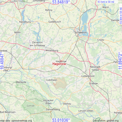
Hagenow GPS coordinates[2]
53° 25' 52.824" North, 11° 11' 29.724" East
| Map corner | latitude | longitude |
|---|---|---|
| Upper-left | 53.84819°, | 10.48847° |
| Center: | 53.43134°, | 11.19159° |
| Lower-right: | 53.01036°, | 11.89472° |
| Map W x H: | 93.2×93.2 km | = 57.9×57.9mi |
| max Lat: | 55.01917° ⇑15.2% North |
| Hagenow: | 53.43134° |
| min Lat: | ⇓84.8% South 47.40724° |
| min Long | Hagenow | max Long |
| 5.92978° | 11.19159° | 14.98853° |
| W 69.8%⇐ | ⇒30.2% E |
Elevation
Elevation of Hagenow is 26 m = 85 ft, and this is 223.1 m = 732 ft below average elevation for this country.
| Max E: |
1256 m = 4121 ft | 88.3% |
| Avg. | 249.1 m = 817 ft | |
| Hagenow | 26 m = 85 ft | |
Min E: |
-5 m = -16 ft | 11.7% |
See also: Germany elevation on elevation.city.
Geographical zone
Hagenow is located in North temperate zone (between Tropic of Cancer and the Arctic Circle). Distance of this North polar circle is 1460.2 km =907.3 mi to North.| Distance of | km | miles | from Hagenow |
|---|---|---|---|
| North Pole | 4066.1 | 2526.6 | to North |
| Arctic Circle | 1460.2 | 907.3 | to North |
| Tropic Cancer | 3335.1 | 2072.3 | to South |
| Equator | 5941 | 3691.6 | to South |


Nearby cities:
15 places around Hagenow: (largest is in red/bold)
• Alt Krenzlin
14.7 km =9.1 mi,  148°
148°
• Dümmer
16.1 km =10 mi,  3°
3°
• Hoort
12.5 km =7.8 mi,  63°
63°
• Kirch Jesar
5.9 km =3.7 mi,  79°
79°
• Kuhstorf
6.4 km =4 mi,  144°
144°
• Körchow
8.6 km =5.3 mi,  278°
278°
• Moraas
7.4 km =4.6 mi,  97°
97°
• Picher
13.8 km =8.6 mi,  132°
132°
• Pritzier
9.5 km =5.9 mi,  232°
232°
• Redefin
9.1 km =5.7 mi,  175°
175°
• Setzin
7.6 km =4.7 mi,  252°
252°
• Sülstorf
14.9 km =9.3 mi,  54°
54°
• Toddin
3.8 km =2.4 mi, 248°
• Vellahn
15.3 km =9.5 mi,  257°
257°
• Wittenburg
11.1 km =6.9 mi,  318°
318°
Sources, notices
• [Note1] Compared only with cities in Germany existing in our database
• [Src1] Map data: © OpenStreetMap contributors (CC-BY-SA)
• [Src2] Other city data from geonames.org with taken over terms of usage.
• [Src3] Geographical zone / Annual Mean Temperature by Robert A. Rohde @ Wikipedia
