Holthusen geodata
Holthusen (Mecklenburg-Vorpommern) is a populated place; located in Germany in Europe/Berlin (GMT+2) time zone. With population of 861 people, there are 7660 cities with bigger population in this country. Compared to other cities in Germany, 86% of cities are located further ↓South; 72% of cities are located further ←West and 79.4% of cities have higher elevation than Holthusen. Note1
Administrative division(s):
- Level 1: Mecklenburg-Vorpommern
- Level 3: Ludwigslust-Parchim
- Level 4: Holthusen


Holthusen GPS coordinates[2]
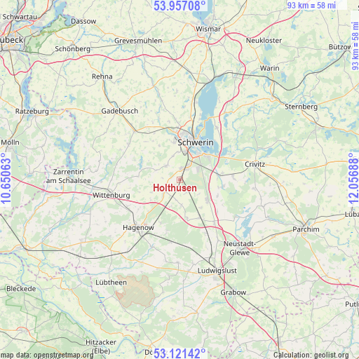
53° 32' 28.716" North, 11° 21' 13.5" East
| Map corner | latitude | longitude |
|---|---|---|
| Upper-left | 53.95708°, | 10.65063° |
| Center: | 53.54131°, | 11.35375° |
| Lower-right: | 53.12142°, | 12.05688° |
| Map W x H: | 92.9×92.9 km | = 57.7×57.7mi |
| max Lat: | 55.01917° ⇑14% North |
| Holthusen: | 53.54131° |
| min Lat: | ⇓86% South 47.40724° |
| min Long | Holthusen | max Long |
| 5.92978° | 11.35375° | 14.98853° |
| W 72%⇐ | ⇒28% E |
Elevation
Elevation of Holthusen is 48 m = 157 ft, and this is 201.1 m = 660 ft below average elevation for this country.
| Max E: |
1256 m = 4121 ft | 79.4% |
| Avg. | 249.1 m = 817 ft | |
| Holthusen | 48 m = 157 ft | |
Min E: |
-5 m = -16 ft | 20.6% |
See also: Germany elevation on elevation.city.
Geographical zone
Holthusen is located in North temperate zone (between Tropic of Cancer and the Arctic Circle). Distance of this North polar circle is 1447.9 km =899.7 mi to North.| Distance of | km | miles | from Holthusen |
|---|---|---|---|
| North Pole | 4053.8 | 2518.9 | to North |
| Arctic Circle | 1447.9 | 899.7 | to North |
| Tropic Cancer | 3347.3 | 2079.9 | to South |
| Equator | 5953.2 | 3699.1 | to South |


Nearby cities:
15 places around Holthusen: (largest is in red/bold)
• Altstadt
10.5 km =6.5 mi,  23°
23°
• Dümmer
10.6 km =6.6 mi,  291°
291°
• Feldstadt
9.8 km =6.1 mi, 20°
• Hoort
6.6 km =4.1 mi,  176°
176°
• Klein Rogahn
7.1 km =4.4 mi,  355°
355°
• Lübesse
9.2 km =5.7 mi,  129°
129°
• Mirow
10.7 km =6.6 mi,  112°
112°
• Neumühle
10.1 km =6.3 mi,  6°
6°
• Paulsstadt
10.7 km =6.6 mi, 17°
• Plate
10.3 km =6.4 mi,  83°
83°
• Schwerin
10.5 km =6.5 mi, 21°
• Stralendorf
5 km =3.1 mi,  318°
318°
• Sülstorf
3.8 km =2.4 mi,  158°
158°
• Weststadt
10.7 km =6.6 mi, 14°
• Wittenförden
9.9 km =6.2 mi,  350°
350°
Sources, notices
• [Note1] Compared only with cities in Germany existing in our database
• [Src1] Map data: © OpenStreetMap contributors (CC-BY-SA)
• [Src2] Other city data from geonames.org with taken over terms of usage.
• [Src3] Geographical zone / Annual Mean Temperature by Robert A. Rohde @ Wikipedia
