Hömberg geodata
Hömberg (Rheinland-Pfalz) is a seat of a fourth-order administrative division; located in Germany in Europe/Berlin (GMT+2) time zone. With population of 327 people, there are 9964 cities with bigger population in this country. Compared to other cities in Germany, 56.1% of cities are located further ↑North; 81.3% of cities are located further →East and 73% of cities have lower elevation than Hömberg. Note1


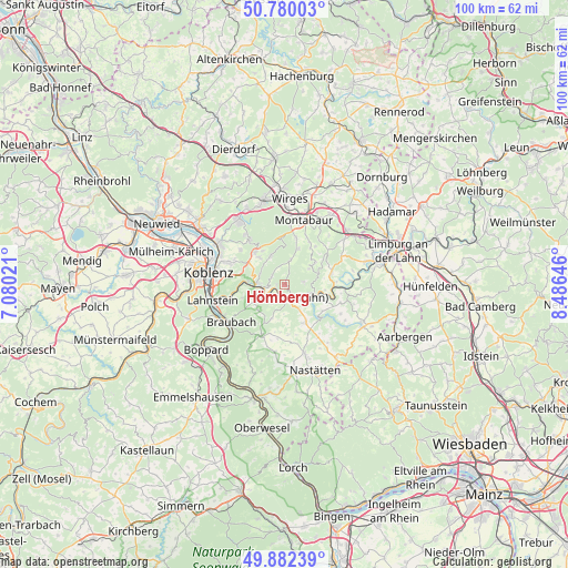
Hömberg GPS coordinates[2]
50° 19' 59.988" North, 7° 46' 59.988" East
| Map corner | latitude | longitude |
|---|---|---|
| Upper-left | 50.78003°, | 7.08021° |
| Center: | 50.33333°, | 7.78333° |
| Lower-right: | 49.88239°, | 8.48646° |
| Map W x H: | 99.8×99.8 km | = 62×62mi |
| max Lat: | 55.01917° ⇑56.1% North |
| Hömberg: | 50.33333° |
| min Lat: | ⇓43.9% South 47.40724° |
| min Long | Hömberg | max Long |
| 5.92978° | 7.78333° | 14.98853° |
| W 18.7%⇐ | ⇒81.3% E |
Elevation
Elevation of Hömberg is 382 m = 1253 ft, and this is 132.9 m = 436 ft above average elevation for this country.
| Max E: |
1256 m = 4121 ft | 27% |
| Hömberg | 382 m 1253 ft | |
| Avg. | 249.1 m = 817 ft | |
Min E: |
-5 m = -16 ft | 73% |
See also: Germany elevation on elevation.city.
Geographical zone
Hömberg is located in North temperate zone (between Tropic of Cancer and the Arctic Circle). Distance of this North polar circle is 1804.6 km =1121.3 mi to North.| Distance of | km | miles | from Hömberg |
|---|---|---|---|
| North Pole | 4410.5 | 2740.6 | to North |
| Arctic Circle | 1804.6 | 1121.3 | to North |
| Tropic Cancer | 2990.6 | 1858.3 | to South |
| Equator | 5596.5 | 3477.5 | to South |


Nearby cities:
15 places around Hömberg: (largest is in red/bold)
• Arzbach
5.6 km =3.5 mi,  334°
334°
• Bad Ems
4.9 km =3 mi,  272°
272°
• Dausenau
1.2 km =0.7 mi, 270°
• Dienethal
3.3 km =2.1 mi,  187°
187°
• Hübingen
5.3 km =3.3 mi,  57°
57°
• Kemmenau
3 km =1.9 mi,  308°
308°
• Misselberg
3.1 km =1.9 mi,  198°
198°
• Nassau
2.4 km =1.5 mi,  150°
150°
• Obernhof
5.1 km =3.2 mi,  111°
111°
• Oberwies
5 km =3.1 mi,  182°
182°
• Sulzbach
4.1 km =2.5 mi,  212°
212°
• Weinähr
4.7 km =2.9 mi,  104°
104°
• Welschneudorf
4.6 km =2.9 mi,  13°
13°
• Winden
3.5 km =2.2 mi,  90°
90°
• Zimmerschied
1.9 km =1.2 mi,  0°
0°
Sources, notices
• [Note1] Compared only with cities in Germany existing in our database
• [Src1] Map data: © OpenStreetMap contributors (CC-BY-SA)
• [Src2] Other city data from geonames.org with taken over terms of usage.
• [Src3] Geographical zone / Annual Mean Temperature by Robert A. Rohde @ Wikipedia
