Dienethal geodata
Dienethal (Rheinland-Pfalz) is a seat of a fourth-order administrative division; located in Germany in Europe/Berlin (GMT+2) time zone. With population of 278 people, there are 10141 cities with bigger population in this country. Compared to other cities in Germany, 56.6% of cities are located further ↑North; 81.4% of cities are located further →East and 61.6% of cities have higher elevation than Dienethal. Note1


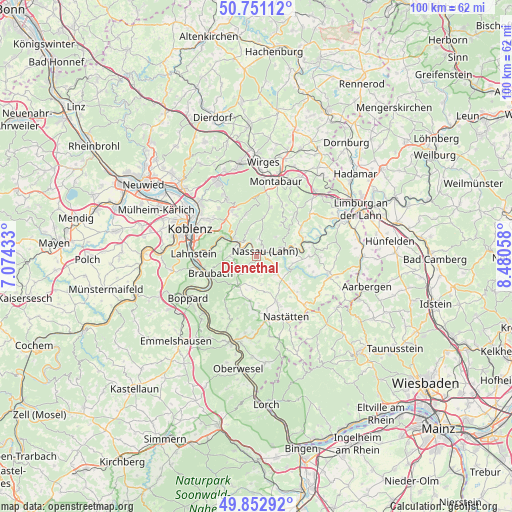
Dienethal GPS coordinates[2]
50° 18' 14.904" North, 7° 46' 38.856" East
| Map corner | latitude | longitude |
|---|---|---|
| Upper-left | 50.75112°, | 7.07433° |
| Center: | 50.30414°, | 7.77746° |
| Lower-right: | 49.85292°, | 8.48058° |
| Map W x H: | 99.9×99.9 km | = 62.1×62.1mi |
| max Lat: | 55.01917° ⇑56.6% North |
| Dienethal: | 50.30414° |
| min Lat: | ⇓43.4% South 47.40724° |
| min Long | Dienethal | max Long |
| 5.92978° | 7.77746° | 14.98853° |
| W 18.6%⇐ | ⇒81.4% E |
Elevation
Elevation of Dienethal is 141 m = 463 ft, and this is 108.1 m = 355 ft below average elevation for this country.
| Max E: |
1256 m = 4121 ft | 61.6% |
| Avg. | 249.1 m = 817 ft | |
| Dienethal | 141 m = 463 ft | |
Min E: |
-5 m = -16 ft | 38.4% |
See also: Germany elevation on elevation.city.
Geographical zone
Dienethal is located in North temperate zone (between Tropic of Cancer and the Arctic Circle). Distance of this North polar circle is 1807.9 km =1123.4 mi to North.| Distance of | km | miles | from Dienethal |
|---|---|---|---|
| North Pole | 4413.8 | 2742.6 | to North |
| Arctic Circle | 1807.9 | 1123.4 | to North |
| Tropic Cancer | 2987.4 | 1856.3 | to South |
| Equator | 5593.3 | 3475.5 | to South |


Nearby cities:
15 places around Dienethal: (largest is in red/bold)
• Becheln
4.4 km =2.7 mi,  253°
253°
• Dausenau
3.3 km =2.1 mi,  346°
346°
• Dessighofen
5.1 km =3.2 mi,  184°
184°
• Dornholzhausen
3.9 km =2.4 mi,  166°
166°
• Hömberg
3.3 km =2.1 mi,  7°
7°
• Kehlbach
5.2 km =3.2 mi,  194°
194°
• Misselberg
0.6 km =0.4 mi,  298°
298°
• Nassau
2 km =1.2 mi,  54°
54°
• Oberwies
1.7 km =1.1 mi, 172°
• Schweighausen
3 km =1.9 mi,  220°
220°
• Singhofen
5.2 km =3.2 mi,  129°
129°
• Sulzbach
1.8 km =1.1 mi,  264°
264°
• Weinähr
5.3 km =3.3 mi,  67°
67°
• Winden
5.1 km =3.2 mi, 50°
• Zimmerschied
5.1 km =3.2 mi,  4°
4°
Sources, notices
• [Note1] Compared only with cities in Germany existing in our database
• [Src1] Map data: © OpenStreetMap contributors (CC-BY-SA)
• [Src2] Other city data from geonames.org with taken over terms of usage.
• [Src3] Geographical zone / Annual Mean Temperature by Robert A. Rohde @ Wikipedia
