Hohenmölsen geodata
Hohenmölsen (Saxony-Anhalt) is a populated place; located in Germany in Europe/Berlin (GMT+2) time zone. With population of 9,772 people, there are 1659 cities with bigger population in this country. Compared to other cities in Germany, 60.9% of cities are located further ↓South; 83.2% of cities are located further ←West and 55.7% of cities have higher elevation than Hohenmölsen. Note1


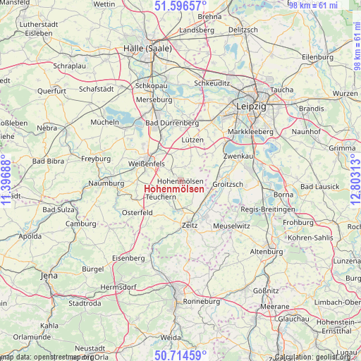
Hohenmölsen GPS coordinates[2]
51° 9' 27.684" North, 12° 6' 0" East
| Map corner | latitude | longitude |
|---|---|---|
| Upper-left | 51.59657°, | 11.39688° |
| Center: | 51.15769°, | 12.1° |
| Lower-right: | 50.71459°, | 12.80313° |
| Map W x H: | 98.1×98.1 km | = 61×61mi |
| max Lat: | 55.01917° ⇑39.1% North |
| Hohenmölsen: | 51.15769° |
| min Lat: | ⇓60.9% South 47.40724° |
| min Long | Hohenmölsen | max Long |
| 5.92978° | 12.1° | 14.98853° |
| W 83.2%⇐ | ⇒16.8% E |
Elevation
Elevation of Hohenmölsen is 184 m = 604 ft, and this is 65.1 m = 214 ft below average elevation for this country.
| Max E: |
1256 m = 4121 ft | 55.7% |
| Avg. | 249.1 m = 817 ft | |
| Hohenmölsen | 184 m = 604 ft | |
Min E: |
-5 m = -16 ft | 44.3% |
See also: Germany elevation on elevation.city.
Geographical zone
Hohenmölsen is located in North temperate zone (between Tropic of Cancer and the Arctic Circle). Distance of this North polar circle is 1713 km =1064.4 mi to North.| Distance of | km | miles | from Hohenmölsen |
|---|---|---|---|
| North Pole | 4318.9 | 2683.6 | to North |
| Arctic Circle | 1713 | 1064.4 | to North |
| Tropic Cancer | 3082.3 | 1915.3 | to South |
| Equator | 5688.2 | 3534.5 | to South |


Nearby cities:
15 places around Hohenmölsen: (largest is in red/bold)
• Deuben
5.7 km =3.5 mi,  199°
199°
• Granschütz
4.5 km =2.8 mi,  311°
311°
• Großgörschen
8.8 km =5.5 mi,  41°
41°
• Gröben
5.5 km =3.4 mi,  226°
226°
• Luckenau
7.6 km =4.7 mi,  189°
189°
• Muschwitz
4.2 km =2.6 mi,  20°
20°
• Nessa
6.5 km =4 mi,  258°
258°
• Nonnewitz
7.6 km =4.7 mi,  167°
167°
• Rippach
8.1 km =5 mi,  341°
341°
• Starsiedel
7.2 km =4.5 mi, 22°
• Taucha
4.2 km =2.6 mi, 340°
• Teuchern
6.7 km =4.2 mi, 232°
• Theißen
7.8 km =4.8 mi,  176°
176°
• Trebnitz
7.4 km =4.6 mi, 198°
• Zorbau
6.6 km =4.1 mi, 305°
Sources, notices
• [Note1] Compared only with cities in Germany existing in our database
• [Src1] Map data: © OpenStreetMap contributors (CC-BY-SA)
• [Src2] Other city data from geonames.org with taken over terms of usage.
• [Src3] Geographical zone / Annual Mean Temperature by Robert A. Rohde @ Wikipedia
