Zorbau geodata
Zorbau (Saxony-Anhalt) is a populated place; located in Germany in Europe/Berlin (GMT+2) time zone. With population of 882 people, there are 7584 cities with bigger population in this country. Compared to other cities in Germany, 61.4% of cities are located further ↓South; 82.1% of cities are located further ←West and 58.1% of cities have higher elevation than Zorbau. Note1


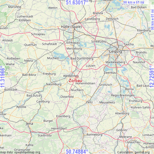
Zorbau GPS coordinates[2]
51° 11' 29.796" North, 12° 1' 22.008" East
| Map corner | latitude | longitude |
|---|---|---|
| Upper-left | 51.63017°, | 11.31966° |
| Center: | 51.19161°, | 12.02278° |
| Lower-right: | 50.74884°, | 12.72591° |
| Map W x H: | 98×98 km | = 60.9×60.9mi |
| max Lat: | 55.01917° ⇑38.6% North |
| Zorbau: | 51.19161° |
| min Lat: | ⇓61.4% South 47.40724° |
| min Long | Zorbau | max Long |
| 5.92978° | 12.02278° | 14.98853° |
| W 82.1%⇐ | ⇒17.9% E |
Elevation
Elevation of Zorbau is 167 m = 548 ft, and this is 82.1 m = 269 ft below average elevation for this country.
| Max E: |
1256 m = 4121 ft | 58.1% |
| Avg. | 249.1 m = 817 ft | |
| Zorbau | 167 m = 548 ft | |
Min E: |
-5 m = -16 ft | 41.9% |
See also: Germany elevation on elevation.city.
Geographical zone
Zorbau is located in North temperate zone (between Tropic of Cancer and the Arctic Circle). Distance of this North polar circle is 1709.2 km =1062 mi to North.| Distance of | km | miles | from Zorbau |
|---|---|---|---|
| North Pole | 4315.1 | 2681.3 | to North |
| Arctic Circle | 1709.2 | 1062 | to North |
| Tropic Cancer | 3086.1 | 1917.6 | to South |
| Equator | 5692 | 3536.8 | to South |


Nearby cities:
15 places around Zorbau: (largest is in red/bold)
• Burgwerben
4.4 km =2.7 mi,  321°
321°
• Dehlitz
4.3 km =2.7 mi,  359°
359°
• Granschütz
2.2 km =1.4 mi,  112°
112°
• Großkorbetha
7.6 km =4.7 mi,  3°
3°
• Hohenmölsen
6.6 km =4.1 mi,  125°
125°
• Langendorf
4.5 km =2.8 mi,  252°
252°
• Markwerben
6.3 km =3.9 mi,  295°
295°
• Muschwitz
6.8 km =4.2 mi,  88°
88°
• Nessa
5.2 km =3.2 mi,  190°
190°
• Rippach
4.8 km =3 mi,  36°
36°
• Schkortleben
5.8 km =3.6 mi, 356°
• Tagewerben
7.1 km =4.4 mi, 315°
• Taucha
4 km =2.5 mi, 87°
• Uichteritz
7.2 km =4.5 mi,  283°
283°
• Weißenfels
3.9 km =2.4 mi,  286°
286°
Sources, notices
• [Note1] Compared only with cities in Germany existing in our database
• [Src1] Map data: © OpenStreetMap contributors (CC-BY-SA)
• [Src2] Other city data from geonames.org with taken over terms of usage.
• [Src3] Geographical zone / Annual Mean Temperature by Robert A. Rohde @ Wikipedia
