Taucha geodata
Taucha (Saxony-Anhalt) is a populated place; located in Germany in Europe/Berlin (GMT+2) time zone. With population of 681 people, there are 8411 cities with bigger population in this country. Compared to other cities in Germany, 61.4% of cities are located further ↓South; 82.9% of cities are located further ←West and 64.8% of cities have higher elevation than Taucha. Note1


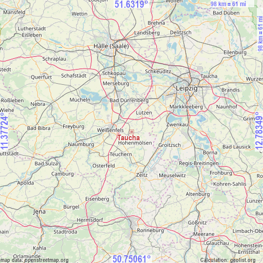
Taucha GPS coordinates[2]
51° 11' 36.096" North, 12° 4' 49.296" East
| Map corner | latitude | longitude |
|---|---|---|
| Upper-left | 51.6319°, | 11.37724° |
| Center: | 51.19336°, | 12.08036° |
| Lower-right: | 50.75061°, | 12.78349° |
| Map W x H: | 98×98 km | = 60.9×60.9mi |
| max Lat: | 55.01917° ⇑38.6% North |
| Taucha: | 51.19336° |
| min Lat: | ⇓61.4% South 47.40724° |
| min Long | Taucha | max Long |
| 5.92978° | 12.08036° | 14.98853° |
| W 82.9%⇐ | ⇒17.1% E |
Elevation
Elevation of Taucha is 121 m = 397 ft, and this is 128.1 m = 420 ft below average elevation for this country.
| Max E: |
1256 m = 4121 ft | 64.8% |
| Avg. | 249.1 m = 817 ft | |
| Taucha | 121 m = 397 ft | |
Min E: |
-5 m = -16 ft | 35.2% |
See also: Germany elevation on elevation.city.
Geographical zone
Taucha is located in North temperate zone (between Tropic of Cancer and the Arctic Circle). Distance of this North polar circle is 1709 km =1061.9 mi to North.| Distance of | km | miles | from Taucha |
|---|---|---|---|
| North Pole | 4314.9 | 2681.2 | to North |
| Arctic Circle | 1709 | 1061.9 | to North |
| Tropic Cancer | 3086.2 | 1917.7 | to South |
| Equator | 5692.2 | 3537 | to South |


Nearby cities:
15 places around Taucha: (largest is in red/bold)
• Burgwerben
7.5 km =4.7 mi,  295°
295°
• Dehlitz
5.8 km =3.6 mi,  315°
315°
• Granschütz
2.2 km =1.4 mi,  243°
243°
• Großgörschen
7.6 km =4.7 mi,  70°
70°
• Gröben
8.2 km =5.1 mi,  198°
198°
• Hohenmölsen
4.2 km =2.6 mi,  160°
160°
• Lützen
8.2 km =5.1 mi,  31°
31°
• Muschwitz
2.8 km =1.7 mi,  90°
90°
• Nessa
7.3 km =4.5 mi,  223°
223°
• Rippach
3.9 km =2.4 mi,  342°
342°
• Röcken
5.8 km =3.6 mi,  24°
24°
• Schkortleben
7.1 km =4.4 mi, 321°
• Starsiedel
4.9 km =3 mi,  56°
56°
• Weißenfels
7.9 km =4.9 mi,  276°
276°
• Zorbau
4 km =2.5 mi,  267°
267°
Sources, notices
• [Note1] Compared only with cities in Germany existing in our database
• [Src1] Map data: © OpenStreetMap contributors (CC-BY-SA)
• [Src2] Other city data from geonames.org with taken over terms of usage.
• [Src3] Geographical zone / Annual Mean Temperature by Robert A. Rohde @ Wikipedia
