Rippach geodata
Rippach (Saxony-Anhalt) is a populated place; located in Germany in Europe/Berlin (GMT+2) time zone. With population of 684 people, there are 8393 cities with bigger population in this country. Compared to other cities in Germany, 61.9% of cities are located further ↓South; 82.7% of cities are located further ←West and 64.2% of cities have higher elevation than Rippach. Note1


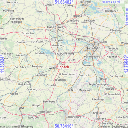
Rippach GPS coordinates[2]
51° 13' 35.76" North, 12° 3' 48.096" East
| Map corner | latitude | longitude |
|---|---|---|
| Upper-left | 51.66482°, | 11.36024° |
| Center: | 51.2266°, | 12.06336° |
| Lower-right: | 50.78416°, | 12.76649° |
| Map W x H: | 97.9×97.9 km | = 60.8×60.8mi |
| max Lat: | 55.01917° ⇑38.1% North |
| Rippach: | 51.2266° |
| min Lat: | ⇓61.9% South 47.40724° |
| min Long | Rippach | max Long |
| 5.92978° | 12.06336° | 14.98853° |
| W 82.7%⇐ | ⇒17.3% E |
Elevation
Elevation of Rippach is 125 m = 410 ft, and this is 124.1 m = 407 ft below average elevation for this country.
| Max E: |
1256 m = 4121 ft | 64.2% |
| Avg. | 249.1 m = 817 ft | |
| Rippach | 125 m = 410 ft | |
Min E: |
-5 m = -16 ft | 35.8% |
See also: Germany elevation on elevation.city.
Geographical zone
Rippach is located in North temperate zone (between Tropic of Cancer and the Arctic Circle). Distance of this North polar circle is 1705.3 km =1059.6 mi to North.| Distance of | km | miles | from Rippach |
|---|---|---|---|
| North Pole | 4311.2 | 2678.9 | to North |
| Arctic Circle | 1705.3 | 1059.6 | to North |
| Tropic Cancer | 3089.9 | 1920 | to South |
| Equator | 5695.9 | 3539.3 | to South |


Nearby cities:
15 places around Rippach: (largest is in red/bold)
• Bad Dürrenberg
7.7 km =4.8 mi,  1°
1°
• Burgwerben
5.5 km =3.4 mi,  265°
265°
• Dehlitz
2.9 km =1.8 mi,  278°
278°
• Granschütz
4.8 km =3 mi,  189°
189°
• Großkorbetha
4.4 km =2.7 mi,  328°
328°
• Lützen
6.4 km =4 mi,  58°
58°
• Muschwitz
5.5 km =3.4 mi,  133°
133°
• Röcken
4 km =2.5 mi,  66°
66°
• Schkortleben
3.7 km =2.3 mi,  300°
300°
• Starsiedel
5.4 km =3.4 mi,  101°
101°
• Taucha
3.9 km =2.4 mi,  162°
162°
• Tollwitz
7 km =4.3 mi,  19°
19°
• Weißenfels
7.2 km =4.5 mi,  247°
247°
• Wengelsdorf
6.2 km =3.9 mi,  346°
346°
• Zorbau
4.8 km =3 mi,  216°
216°
Sources, notices
• [Note1] Compared only with cities in Germany existing in our database
• [Src1] Map data: © OpenStreetMap contributors (CC-BY-SA)
• [Src2] Other city data from geonames.org with taken over terms of usage.
• [Src3] Geographical zone / Annual Mean Temperature by Robert A. Rohde @ Wikipedia
