Hochstadt am Main geodata
Hochstadt am Main (Bavaria) is a populated place; located in Germany in Europe/Berlin (GMT+2) time zone. With population of 1,702 people, there are 5507 cities with bigger population in this country. Compared to other cities in Germany, 59.9% of cities are located further ↑North; 69.5% of cities are located further ←West and 58.8% of cities have lower elevation than Hochstadt am Main. Note1
Administrative division(s):
- Level 1: Bavaria
- Level 2: Upper Franconia
- Level 3: Landkreis Lichtenfels
- Level 4: Hochstadt a.Main


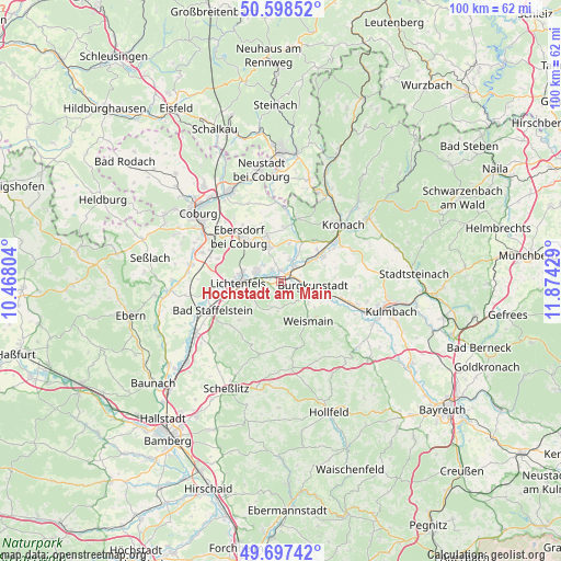
Hochstadt am Main GPS coordinates[2]
50° 9' 0.324" North, 11° 10' 16.176" East
| Map corner | latitude | longitude |
|---|---|---|
| Upper-left | 50.59852°, | 10.46804° |
| Center: | 50.15009°, | 11.17116° |
| Lower-right: | 49.69742°, | 11.87429° |
| Map W x H: | 100.2×100.2 km | = 62.3×62.3mi |
| max Lat: | 55.01917° ⇑59.9% North |
| Hochstadt am Main: | 50.15009° |
| min Lat: | ⇓40.1% South 47.40724° |
| min Long | Hochstadt am Ma | max Long |
| 5.92978° | 11.17116° | 14.98853° |
| W 69.5%⇐ | ⇒30.5% E |
Elevation
Elevation of Hochstadt am Main is 283 m = 928 ft, and this is 33.9 m = 111 ft above average elevation for this country.
| Max E: |
1256 m = 4121 ft | 41.2% |
| Hochstadt am Main | 283 m 928 ft | |
| Avg. | 249.1 m = 817 ft | |
Min E: |
-5 m = -16 ft | 58.8% |
See also: Germany elevation on elevation.city.
Geographical zone
Hochstadt am Main is located in North temperate zone (between Tropic of Cancer and the Arctic Circle). Distance of this North polar circle is 1825 km =1134 mi to North.| Distance of | km | miles | from Hochstadt am Main |
|---|---|---|---|
| North Pole | 4430.9 | 2753.2 | to North |
| Arctic Circle | 1825 | 1134 | to North |
| Tropic Cancer | 2970.2 | 1845.6 | to South |
| Equator | 5576.2 | 3464.9 | to South |


Nearby cities:
15 places around Hochstadt am Main: (largest is in red/bold)
• Altendorf
7.3 km =4.5 mi,  181°
181°
• Altenkunstadt
6.3 km =3.9 mi,  116°
116°
• Bad Staffelstein
13.2 km =8.2 mi,  246°
246°
• Burgkunstadt
5.9 km =3.7 mi,  100°
100°
• Kueps Oberfranken
8.8 km =5.5 mi,  57°
57°
• Lichtenfels
8 km =5 mi,  266°
266°
• Marktgraitz
4.1 km =2.5 mi,  23°
23°
• Marktzeuln
1.9 km =1.2 mi,  350°
350°
• Michelau
4.4 km =2.7 mi,  287°
287°
• Mitwitz
11.5 km =7.1 mi,  13°
13°
• Redwitz an der Rodach
3.7 km =2.3 mi,  45°
45°
• Schneckenlohe
7.1 km =4.4 mi, 13°
• Sonnefeld
7.9 km =4.9 mi,  340°
340°
• Weidhausen bei Coburg
6.3 km =3.9 mi, 339°
• Weismain
8.7 km =5.4 mi,  145°
145°
Sources, notices
• [Note1] Compared only with cities in Germany existing in our database
• [Src1] Map data: © OpenStreetMap contributors (CC-BY-SA)
• [Src2] Other city data from geonames.org with taken over terms of usage.
• [Src3] Geographical zone / Annual Mean Temperature by Robert A. Rohde @ Wikipedia
