Mitwitz geodata
Mitwitz (Bavaria) is a populated place; located in Germany in Europe/Berlin (GMT+2) time zone. With population of 3,076 people, there are 3936 cities with bigger population in this country. Compared to other cities in Germany, 57.7% of cities are located further ↑North; 70.1% of cities are located further ←West and 61.5% of cities have lower elevation than Mitwitz. Note1
Administrative division(s):
- Level 1: Bavaria
- Level 2: Upper Franconia
- Level 3: Landkreis Kronach
- Level 4: Mitwitz, Markt


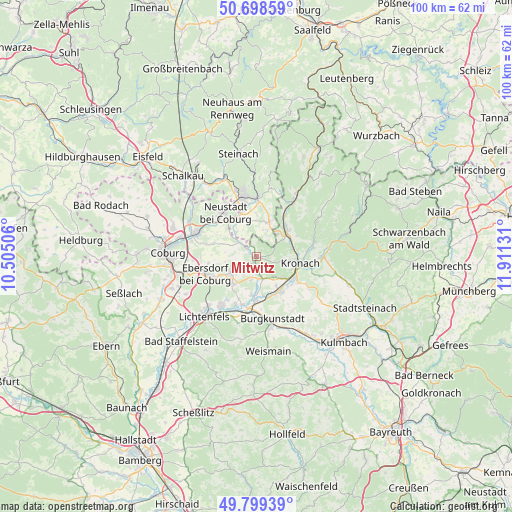
Mitwitz GPS coordinates[2]
50° 15' 3.996" North, 11° 12' 29.448" East
| Map corner | latitude | longitude |
|---|---|---|
| Upper-left | 50.69859°, | 10.50506° |
| Center: | 50.25111°, | 11.20818° |
| Lower-right: | 49.79939°, | 11.91131° |
| Map W x H: | 100×100 km | = 62.1×62.1mi |
| max Lat: | 55.01917° ⇑57.7% North |
| Mitwitz: | 50.25111° |
| min Lat: | ⇓42.3% South 47.40724° |
| min Long | Mitwitz | max Long |
| 5.92978° | 11.20818° | 14.98853° |
| W 70.1%⇐ | ⇒29.9% E |
Elevation
Elevation of Mitwitz is 299 m = 981 ft, and this is 49.9 m = 164 ft above average elevation for this country.
| Max E: |
1256 m = 4121 ft | 38.5% |
| Mitwitz | 299 m 981 ft | |
| Avg. | 249.1 m = 817 ft | |
Min E: |
-5 m = -16 ft | 61.5% |
See also: Germany elevation on elevation.city.
Geographical zone
Mitwitz is located in North temperate zone (between Tropic of Cancer and the Arctic Circle). Distance of this North polar circle is 1813.8 km =1127 mi to North.| Distance of | km | miles | from Mitwitz |
|---|---|---|---|
| North Pole | 4419.7 | 2746.3 | to North |
| Arctic Circle | 1813.8 | 1127 | to North |
| Tropic Cancer | 2981.5 | 1852.6 | to South |
| Equator | 5587.4 | 3471.8 | to South |


Nearby cities:
15 places around Mitwitz: (largest is in red/bold)
• Ebersdorf
9.5 km =5.9 mi,  335°
335°
• Föritz
10.2 km =6.3 mi,  9°
9°
• Hochstadt am Main
11.5 km =7.1 mi,  193°
193°
• Kronach
9 km =5.6 mi,  98°
98°
• Kueps Oberfranken
8.1 km =5 mi,  143°
143°
• Marktgraitz
7.6 km =4.7 mi, 187°
• Marktzeuln
9.8 km =6.1 mi,  197°
197°
• Neuhaus-Schierschnitz
7.2 km =4.5 mi,  18°
18°
• Neustadt bei Coburg
10.7 km =6.6 mi,  324°
324°
• Redwitz an der Rodach
8.7 km =5.4 mi,  179°
179°
• Schneckenlohe
4.5 km =2.8 mi, 193°
• Sonnefeld
6.6 km =4.1 mi,  234°
234°
• Stockheim
8.1 km =5 mi,  40°
40°
• Weidhausen bei Coburg
7.2 km =4.5 mi,  222°
222°
• Weißenbrunn
11.6 km =7.2 mi,  119°
119°
Sources, notices
• [Note1] Compared only with cities in Germany existing in our database
• [Src1] Map data: © OpenStreetMap contributors (CC-BY-SA)
• [Src2] Other city data from geonames.org with taken over terms of usage.
• [Src3] Geographical zone / Annual Mean Temperature by Robert A. Rohde @ Wikipedia
